tallyho8
Elite Member
- Joined
- Aug 1, 2004
- Messages
- 4,998
- Tractor
- Kubota L4400, Kubota ZD326
The Mississippi was supposed to crest at record levels in New Orleans on the 23rd but since they opened the Morganza and Bonnet Carre' spillways the river is cresting in New Orleans today instead and at much lower levels than it would have been if the spillways were not opened.
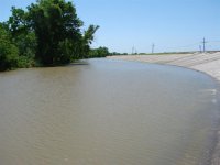
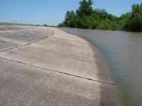
Attached are today's photos of my batture land behind the levee and you can see that the river is still 10' below the levee. All good news for us.")
Attached are today's photos of my batture land behind the levee and you can see that the river is still 10' below the levee. All good news for us.