How to figure out property line over hills/woods

   / How to figure out property line over hills/woods #31  
I have one property line that goes through gullys, over a hill, and through some woods. Both corners are marked with stakes. I placed white markers on each stake and had a buddy fly me over. I was planning on taking photos of my whole place, but during the flight we made a pass around the property and I got one great photo showing both corners. After having the photo, I put a straight line between the two points and looked at trees and identifying features. My neighbor had somebody walk the line and lay it out with a GPS. We were both within a foot of each other. We weren't building a fence, so this was all just for fun, but we were surprised to be so close.

I'm wondering if Google Earth might have enough resolution in your area to do something similar. I don't think I'd build a fence by it, but it would be fun just for comparison's sake.

In the overall scheme of things, when you compare the cost of a good fence and the labor you'll do building it, a surveyor's fee is "chicken feed." I'd hire the surveyor and count his fee as money well spent.:)
 
   / How to figure out property line over hills/woods
  • Thread Starter
#32  
SteveC, thanks for the laser idea. That is really a unique idea that sounds pretty good!
 
   / How to figure out property line over hills/woods
  • Thread Starter
#33  
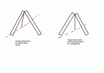
Beenthere, I think I understand your tripod idea. If you clear the top of the hill so that the line is suspended from the ground, a very taught wire will want to pull itself straight.

With that said, if you have the tripod in the incorrect location in the center of the run, the horizontal wire you stretch will want to pull your vertical wire to one side or the other. When you hit dead center, the vertical will be exactly plumb. I have drawn a picture. Please let me know if this is what you mean:

Thanks,
Joseph
 

Attachments

  • tripod.GIF
    tripod.GIF
    6.3 KB · Views: 693
   / How to figure out property line over hills/woods #34  
SteveC, thanks for the laser idea. That is really a unique idea that sounds pretty good!

I used to be a mechanical designer before I became old and and umemployed. :mad:

I found over the years that not knowing how things are supposed to be done is sometimes an advantage when it comes to solving problems. It allows me to use my imagination to explore other ways of doing things that are normaly done some other way because I have no preconcieved ideas of the "right way" to do things.:confused:

As a result I have invented several mechanical devices that have been adopted as "M.E.T." (most effective technology) for use in chemical processing plants world wide.

Using the lasers to set the arbor of my table saw perpendicular to the fence is by far the most accurate method I have ever used. When I figured out how to do it the results were amazing. My cheap old cast iron Craftsman saw now cuts great, the blade doesn't rub at all on either side of the cut even when using thin kerf Frued blades.:D:D
 
   / How to figure out property line over hills/woods #35  
The way we learned in Forest Surveying class in the early 70's was to use a transit.

First, don't rely on the azimuth on the old survey. Things change and if you look at aerial navigation charts, they show the latest compass deviation and it changes frequently. So the azimuth is only a starting point.

Set up the transit (rent one) on a corner and shoot the azimuth. Use a plumb bob to center the transit exactly over the corner. Set a pin (best to use a stake with a nail in it, the nail being exactly under the plumb bob) out 100 ft.--measure carefully. Move the transit to the pin, then sight back to your corner. You will need a partner with a plumb bob and sight on the string holding the plumb bob. The neat thing about a transit is that it rotates vertically; i.e., it flips up and over to now shoot forward. There is no error from turning. So flip it forward, go out another 100 ft. and set another pin, sight back to your last pin, etc.

What you are doing is projecting a straight line. It doesn't matter if you hit your next corner, you just need to lay out a straight line from one corner to somewhere near the second corner.

When you get out the distance shown on your plat map--say, 2640 ft--you should be near your next corner. Measure the error which should be 90 degrees from your ending point. Then you prorate that error over your line. So if your line is 1000 ft. long and you are off 10 feet, you adjust 1 foot for every 100 ft. along the line from your starting point. If all your measurements are done carefully and correctly, your line should be right on.

You are going thru the woods, you say? What if you have a tree right on your line? You will need to offset. Go 2 pins back, say to the pin at the 300 ft. mark. Measure an arbitrary distance, say exactly 5 feet exactly 90 degrees off to the side of your line. Do the same at the 400 ft. pin, set up the transit at that one, sight back to the 300 footer, flip the scope up and over and sight forward.

Offsets introduce error and you want to avoid them if possible. It is probably better if you have a known obstacle to offset from your starting point and run a perfectly straight line than to have an offset in the middle.

Trying to lay out a property line with a compass is a waste of time. You won't be accurate enough. 1 degree of error equates to 92 feet at one mile. A compass with 1/2 degree error sounds pretty good, but it will still give you as much as 23 feet of error at half a mile and that doesn't even count operator error, errors with declination, or local attraction.
 
   / How to figure out property line over hills/woods #36  
Beenthere, I think I understand your tripod idea. If you clear the top of the hill so that the line is suspended from the ground, a very taught wire will want to pull itself straight.

With that said, if you have the tripod in the incorrect location in the center of the run, the horizontal wire you stretch will want to pull your vertical wire to one side or the other. When you hit dead center, the vertical will be exactly plumb. I have drawn a picture. Please let me know if this is what you mean:

Thanks,
Joseph

Great drawing. Just the way I envisioned it. And a plumb line hanging separate from the top of the tripod should help verify being on-line. Setting up on the top of the hill at minimum, and other locations if the wire wants to drop to the ground, should do the trick. Maybe just a two-leg support would work, as long as it doesn't fall over (and it shouldn't).
I'd think that would get you pretty close to being straight.

Now, you won't hurt my feelings if you try something else suggested. :)
 
   / How to figure out property line over hills/woods #37  
The way we learned in Forest Surveying class in the early 70's was to use a transit.

First, don't rely on the azimuth on the old survey. Things change and if you look at aerial navigation charts, they show the latest compass deviation and it changes frequently. So the azimuth is only a starting point.

Set up the transit (rent one) on a corner and shoot the azimuth. Use a plumb bob to center the transit exactly over the corner. Set a pin (best to use a stake with a nail in it, the nail being exactly under the plumb bob) out 100 ft.--measure carefully. Move the transit to the pin, then sight back to your corner. You will need a partner with a plumb bob and sight on the string holding the plumb bob. The neat thing about a transit is that it rotates vertically; i.e., it flips up and over to now shoot forward. There is no error from turning. So flip it forward, go out another 100 ft. and set another pin, sight back to your last pin, etc.

What you are doing is projecting a straight line. It doesn't matter if you hit your next corner, you just need to lay out a straight line from one corner to somewhere near the second corner.

When you get out the distance shown on your plat map--say, 2640 ft--you should be near your next corner. Measure the error which should be 90 degrees from your ending point. Then you prorate that error over your line. So if your line is 1000 ft. long and you are off 10 feet, you adjust 1 foot for every 100 ft. along the line from your starting point. If all your measurements are done carefully and correctly, your line should be right on.

You are going thru the woods, you say? What if you have a tree right on your line? You will need to offset. Go 2 pins back, say to the pin at the 300 ft. mark. Measure an arbitrary distance, say exactly 5 feet exactly 90 degrees off to the side of your line. Do the same at the 400 ft. pin, set up the transit at that one, sight back to the 300 footer, flip the scope up and over and sight forward.

Offsets introduce error and you want to avoid them if possible. It is probably better if you have a known obstacle to offset from your starting point and run a perfectly straight line than to have an offset in the middle.

Trying to lay out a property line with a compass is a waste of time. You won't be accurate enough. 1 degree of error equates to 92 feet at one mile. A compass with 1/2 degree error sounds pretty good, but it will still give you as much as 23 feet of error at half a mile and that doesn't even count operator error, errors with declination, or local attraction.


Excelent description on how to do it! Thank you. Now I get to shop for a transit...I have always wanted one!:D:D
 
   / How to figure out property line over hills/woods #38  
Pilot
Your suggestion is one I also learned in Forestry. And it is the best if familiar with a transit and can get hands on one.
Your method will likely be the one the surveyors use. They may go out as far as they can see to place a marker, and measure to that point. Then leapfrog to the next point further out. When they can tie into the end point, they will likely turn that angle and with the distances, figure out what the offsets need to be at each intermediate marker.
Prolly the best way, if a transit can be used.
 
   / How to figure out property line over hills/woods
  • Thread Starter
#39  
Ok, I have been poking around on the internet. I think I figured out what Pilot is saying.

From my last reference stake already there from the survey, I have 2 I can see back to the road. So I have something like this:

River bank and hill--existing stake 3--existing stake 2---existing stake 1--road

So, I would setup at stake 3 that is already there. Then, shoot backwards to stake 2. With that angle setting, I would flip the transit 180 degrees and then shoot forward toward the river bank/hill - as far as I could see then set a stake there. Then move to that new stake and shoot backwards towards 3, flip, and repeat.

So, a couple of key points that I have heard are:

1.) The transit must be level and plumb bob'd on the reference stake.
2.) A helper must hold a plumb bob infront of you to mark the next point accurately.

Are there any other key tips for this?

Thanks again to everyone for their help!

Joseph
 
   / How to figure out property line over hills/woods
  • Thread Starter
#40  
One question I have about Pilot's method. Does the survey plat footage show straight line footage? Or, does that footage account for going up and down hills (ground contour)?

Thanks,
Joseph
 
 
Top