1930
Platinum Member
- Joined
- Sep 9, 2018
- Messages
- 851
- Location
- Brandon/Ocala Florida
- Tractor
- Kubota B6100E Kubota L 2501 Kubota T1460
We all have our strong points, mine is not schooling.
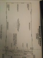
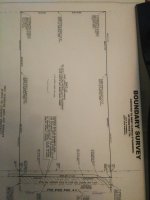
This is the property Im clearing, Ime at the point where I am gonna start clearing the spot that I intend to use for the home and yard.
I dont know any way to figure out where the center of property is ( cause that where I want the house to be ) because I cant run a string and make an X ( too many trees still )
I figure that I can come X distance across from each corner.......for instance front of property and rear of property shows to be 330 feet.....ok I can measure across the front and rear of property starting at each corner and make my mark, then I can get a string line running front to rear and that will be two lines done.
Then I can measure up and down X amount from the front and rear of property both sides and run another string.
I hope this makes sense.
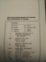
On my survey I see that they show two measurements for the sides of the property.....one is calculated and the other is field? I cant remember why there are both numbers?
The survey I show is facing the correct way, Obeed Ridge Rd is the dirt road in front of my property.
I want one acre rectangular cut out same shape as my property....I dont know how to do this problem.
Im not looking for dead nuts accuracy but anything worth doing is worth doing as best as I am able.
Thanks
This is the property Im clearing, Ime at the point where I am gonna start clearing the spot that I intend to use for the home and yard.
I dont know any way to figure out where the center of property is ( cause that where I want the house to be ) because I cant run a string and make an X ( too many trees still )
I figure that I can come X distance across from each corner.......for instance front of property and rear of property shows to be 330 feet.....ok I can measure across the front and rear of property starting at each corner and make my mark, then I can get a string line running front to rear and that will be two lines done.
Then I can measure up and down X amount from the front and rear of property both sides and run another string.
I hope this makes sense.
On my survey I see that they show two measurements for the sides of the property.....one is calculated and the other is field? I cant remember why there are both numbers?
The survey I show is facing the correct way, Obeed Ridge Rd is the dirt road in front of my property.
I want one acre rectangular cut out same shape as my property....I dont know how to do this problem.
Im not looking for dead nuts accuracy but anything worth doing is worth doing as best as I am able.
Thanks