Good way to record the location of gravity drain pipe

   / Good way to record the location of gravity drain pipe #1  

RichardMH

New member
Joined
Jan 1, 2013
Messages
9
Location
Ontario
Tractor
Kubota L3560
Our contractor will be digging a gravity drain approximately 11 ft below grade from the foundation of our new house to outfall approximately 400 ft away. Due to the layout of our house and contours around it, the drain pipe will need to change directions a few times. It will be very difficult to know the path of the underground pipe a few years from now.

I am looking for a way to record the location of the drain pipe just in case we need to access it later. I have a handheld GPS receiver which I can use to record the path of the pipe very quickly and easily but it is only good down to 10 ft or so which is not good enough. So apart from burying some metal objects near ground surface along the path which I can pick up later with a metal detector, is there any other way I can record the path fairly accurately and easily ?

I am looking further down the road when we will have quite a lot of additional buried lines (internet, low voltage etc) leaving the house in different directions so I would rather find a way to record their positions if possible and not dropping metal objects everywhere. But if this is the easiest and cheapest way, so be it...

I would love to be able to afford a nice total station to record all the locations I want to across our lot (around 60 acres). I used one a long time ago when I started my engineering career in setting out but they are very expensive so not a realistic option for me !

Would love to hear your ideas.
 
   / Good way to record the location of gravity drain pipe #2  
Lay a thin copper wire in trench with pipe. That is common practice with utility
 
   / Good way to record the location of gravity drain pipe #3  
Lots of photos.

Got a friend with a drone?

Bruce
 
   / Good way to record the location of gravity drain pipe #4  
I would just drive some rebar along the path, and maybe record the distance between them.
 
   / Good way to record the location of gravity drain pipe #5  
I'm a utility engineer and use a trimble Geo 7X which is accurate to 4 inches with the software we have on it and can be upgraded to decimeter accuracy. About $10K though with the antenna. Then you need Trimble software to convert the data which is thousands more.

Just hire a surveyor. Will be much cheaper.
 
   / Good way to record the location of gravity drain pipe #6  
- I'd take measurements from two corners of your house to the first bend and record them.
- Then make an arbitrary point about 10'-20' to the side of the first bend and take two more measurements from the house corners to the arbitrary point and record those.
- Then take measurements from the first bend and the arbitrary point to the 2nd bend.
- Record and repeat with a 2nd arbitrary point, etc... until you get all of the bends mapped.

Easy peasy.

Then draw out a little diagram with all your points and measurements and put it in your big binder of house data (everyone should have one).

Make a copy of everything in your big binder of house data (everyone should have one) and keep it in a safe deposit box at your bank, credit union, etc...
 
   / Good way to record the location of gravity drain pipe #7  
Can you just draw a map using measurements from points that’ll hopefully be there years later?
 
   / Good way to record the location of gravity drain pipe #8  
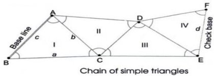
Like this...

Your house wall is the baseline.
C is the first bend.
D is your first arbitrary point.
E is your 2nd bend.
F is your next arbitrary point.


attachment.php

987D7A72-6BB4-4CA8-9C36-E9754F4BAE3E.jpeg

(stolen from here What is Triangulation Surveying? Operations, Applications and Advantages )

You can't go wrong with this if you record accurate measurements and keep you tape measure straight.

If you cant get to each bend, just make more arbitrary points. Piece of cake. No electronics required. No need to worry if in 15 years the technology you used to record it is compatible with the current tech, etc...
 
   / Good way to record the location of gravity drain pipe #9  
You could maybe capture a google Earth shot and draw the pipe line in with an image editor...then print and or store as a digital image...
 
   / Good way to record the location of gravity drain pipe #10  
Like this...

Your house wall is the baseline.
C is the first bend.
D is your first arbitrary point.
E is your 2nd bend.
F is your next arbitrary point.


620010d1567734829-good-way-record-location-gravity-987d7a72-6bb4-4ca8-9c36-e9754f4bae3e

View attachment 620010

(stolen from here What is Triangulation Surveying? Operations, Applications and Advantages )

You can't go wrong with this if you record accurate measurements and keep you tape measure straight.

If you cant get to each bend, just make more arbitrary points. Piece of cake. No electronics required. No need to worry if in 15 years the technology you used to record it is compatible with the current tech, etc...

This is the way to do it. I used a modified version of this since I have multiple buildings and I can reference off of them. I also include the depth if I can get it. (keeping in mind that the depth will change based on erosion, grading, etc.)
 
 
Top