Working rail roads and their tracks.

   / Working rail roads and their tracks. #491  
If only those rails could talk... :thumbsup:

True. They are mysterious and if they could, would tell many tales. Just 1/4 mile down range from that picture is where NC Wyeth was killed crossing those very tracks in 1945.
1972 was the end. A 1/2 mile stretch was flooded beyond repair and despite the enormous population growth that followed, they were never repaired.
Never ceases to amaze me the capital invested in railroads only to abandon them.
 
   / Working rail roads and their tracks. #492  

Thanks Bruce. Nice map. The very southeast corner between Chadds Ford and Granogue is my location. If you look a little north, youll see Doe Run Station. That is where cattle were shipped all the way from Texas to the 14,000 acre King Ranch in Unionville & Coatesville. Biggest ranch on the east coast.
 
   / Working rail roads and their tracks. #493  
Thanks Bruce. Nice map. The very southeast corner between Chadds Ford and Granogue is my location. If you look a little north, youll see Doe Run Station. That is where cattle were shipped all the way from Texas to the 14,000 acre King Ranch in Unionville & Coatesville. Biggest ranch on the east coast.

14,000 acres, Lol How about 1 million acres?

Aztec Land & Cattle Company - Wikipedia
 
   / Working rail roads and their tracks. #494  
   / Working rail roads and their tracks. #495  
Lol Can you read? :confused2:
I said

" 14,000 acre King Ranch in Unionville & Coatesville. Biggest ranch on the east coast."


Yes, I can read, your point was 14k acres was a big ranch on the East Coast. My point was 14k acres is a small farm in Arizona:laughing:
 
   / Working rail roads and their tracks. #496  
Thanks Bruce. Nice map. The very southeast corner between Chadds Ford and Granogue is my location. If you look a little north, youll see Doe Run Station. That is where cattle were shipped all the way from Texas to the 14,000 acre King Ranch in Unionville & Coatesville. Biggest ranch on the east coast.

I've been driving to a local Menard's a lot lately to get building supplies for our garage addition. There's a bypass around the SW side of town. In a 3 mile stretch there's 4 overpasses over RR grades. 1 has tracks. The other 3 are abandoned. And every couple decades they rebuild/repair the bridges over nothing. :rolleyes:
 
   / Working rail roads and their tracks. #497  
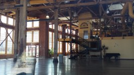
Photo I forgot to post back in August while on a camping trip. This is the old roundhouse in Evanston WY. The old turntable and the place turned into a reception type hall. I took that photo through the window.
20200816_140021.jpg
20200816_140232.jpg
 
   / Working rail roads and their tracks. #499  
I've been driving to a local Menard's a lot lately to get building supplies for our garage addition. There's a bypass around the SW side of town. In a 3 mile stretch there's 4 overpasses over RR grades. 1 has tracks. The other 3 are abandoned. And every couple decades they rebuild/repair the bridges over nothing. :rolleyes:

Probably cheaper to maintain the bridges than replace them with new roadbed at grade.

besides the overpass gives a place for the vagrants to sleep out of the weather.:laughing:
 
   / Working rail roads and their tracks. #500  
Probably cheaper to maintain the bridges than replace them with new roadbed at grade.

besides the overpass gives a place for the vagrants to sleep out of the weather.:laughing:

We have more than our share of homeless people, but they are more in town. These bridges are out of town. And they built them all up above grade to go over the tracks that were at grade before the highway was there. It's kind of a whoopdeedoo road now with all the built up overpasses. And it's a high wind area to boot. They frequently have to close it when trucks, campers and manufactured houses get blown over up on the elevations.

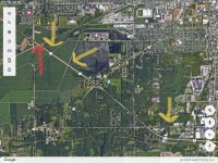
The red arrow is a live track. The three yellow arrows are abandoned. They were live when the highway was built around 1970 and gradually were let go.

The yellow one on the right went between South Bend and Indianapolis. Took a lot of product from Studebaker and Kaiser Jeep (now AM General). Just to the right of the top of that right arrow is still an active AM General test track for on and off road testing of Hummers.

The middle yellow arrow used to be the NJI&I. It went about 8 miles south to tie into the east/west Wabash RR line. The NJI&I was built by the Singer Sewing Machine Company. Hard to believe that a sewing machine company was so large that it had it's own railroad, but they had 4 HUGE buildings and made all of their wood cabinets and sewing machines here in South Bend. They are one of the main reasons northern Indiana was deforested of hardwoods. There was that much of a demand for sewing machines. :eek:
New Jersey, Indiana and Illinois Railroad - Wikipedia

The left yellow arrow went to the southwest, over towards Kankakee, Illinois. I've given the history of that line before. Part of it runs through one of my properties and there's an old railroad trestle still there on the property. I remember trains on it until the 80s.

The red arrow was the former Grand Trunk Western, now CN. That comes from Detroit through South Bend, then runs SW and eventually turns back NW to Chicago.
369EBEAC-D7DB-4022-892D-6466DF290178.jpeg
 

Tractor & Equipment Auctions

Handlair 555 Grain Vac (A50514)
Handlair 555 Grain...
Wolverine Mini Skid Steer Grapple Bucket (A50514)
Wolverine Mini...
2014 BMW X3 AWD SUV (A50324)
2014 BMW X3 AWD...
2025 REDELIFT CPD25-XD4 FORKLIFT (A52141)
2025 REDELIFT...
2012 Chevrolet Equinox 1LT SUV (A50324)
2012 Chevrolet...
2015 JLG Triple-L Flatbed T/A Trailer (A50323)
2015 JLG Triple-L...
 
Top