StanR
Gold Member
I should be closing on the below 37.5 acres in the next few weeks. I am past pumped! I will start a thread when we close to show the improvements and ask for advice. Maybe I just did.
I have several issues that I need to handle pretty fast:
There is an erosion problem that I think was made worse by something the previous owner allowed to happen; I have piles of saw dust sitting near the entrance.
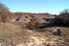
I have the below picture labeled several ways and will post a legend.
I divided the property into 4 sections: A=NE ,B=SE ,C=SW,D=SW.
All improvements (well and electric) are by the letter C and there is no septic yet.
The middle line is contour with 4 hash marks.
There are four sections: numbers 1,2,3,4.
SOIL TYPES
Section A/B an iron ore type soil.
Section C/D a sandy loan
Elevations by section:
A=361'
B= 362'
C=349'
D=345'
Elevations using hash marks on curved line thru the center:
Top to bottom of dry creek thru middle
1st = 333
2nd=327'
3rd= 323'
4th =313'
Nice contours for a small track.
I am sending in a soil test tomorrow
Issues
Piles of saw dust. See the white marks under letter A. The owner was paid by the local saw mill so they could dump the saw dust there. They were supposed to come back and level out. Did not happen.
I understand this is saw dust only and was standard for the area.
I need to spread this around... I was thinking in sections C/D that this may help the sandy soil.
I am not sure if is would help the iron ore type soil.
The other issue is by what manner to procede once a decision is made.
I was thinking of using a mature spreader??
The local USDA soil conservation office, the local agricultural agent, and the state wildlife biologists all said they would be happy to come out.
Do you know if the saw dust will improve one of my soil types more that the other? Also, what are the drawbacks.
EROSION
The highest elevation is in area A/B
The number 1-4 show the erosion area. The worst are #1 and #2
I think the saw dust disturbed the normal flow of water draining from the land.
So after we solve the saw dust problem what is the best way to solve the erosion issue?
I assume the land will have to be recontoured.
The above is dozer work.
I have the following equipment:
Kubota MX 5100 4x4 w/fel, draft control and 1 rear remote, rear tires filled with water
I see the need for a grapple so I am going to order the 3rd function kit.
6 ft shredder
6 ft disk
9 shank cultivator or ripper
6 ft rake
6 ft rear blade
Seeder/fertilizer spreader
16 inch ford 2 bottom plow
Potato plow
Cultipacker
I have the blades to make a 6 foot land leveler. (I have a very long drive way)
This brings me here:
1. moving the saw dust. Manure spreader?
I would also consider hiring someone? Not sure of the cost of the time
2. Erosion. My land is a little higher than my neighbor on the A/B side.
Do they just move some dirt from the higher areas to low area? I know that will change to top layer, just do not know if bad or good??
Do we bring in some dirt to fill the deepest erosion areas?
I am sure the people that come out will have ideas and/or suggestions.
I have close to zero experience.
So any words of wisdom or just things to watch for so I do not make any major mistakes would be appreciated.
Thanks,
Stan
Map

pictures of saw dust

SW Corner

SE Corner

NW

picture looking west at entrance

I have several issues that I need to handle pretty fast:
There is an erosion problem that I think was made worse by something the previous owner allowed to happen; I have piles of saw dust sitting near the entrance.
I have the below picture labeled several ways and will post a legend.
I divided the property into 4 sections: A=NE ,B=SE ,C=SW,D=SW.
All improvements (well and electric) are by the letter C and there is no septic yet.
The middle line is contour with 4 hash marks.
There are four sections: numbers 1,2,3,4.
SOIL TYPES
Section A/B an iron ore type soil.
Section C/D a sandy loan
Elevations by section:
A=361'
B= 362'
C=349'
D=345'
Elevations using hash marks on curved line thru the center:
Top to bottom of dry creek thru middle
1st = 333
2nd=327'
3rd= 323'
4th =313'
Nice contours for a small track.
I am sending in a soil test tomorrow
Issues
Piles of saw dust. See the white marks under letter A. The owner was paid by the local saw mill so they could dump the saw dust there. They were supposed to come back and level out. Did not happen.
I understand this is saw dust only and was standard for the area.
I need to spread this around... I was thinking in sections C/D that this may help the sandy soil.
I am not sure if is would help the iron ore type soil.
The other issue is by what manner to procede once a decision is made.
I was thinking of using a mature spreader??
The local USDA soil conservation office, the local agricultural agent, and the state wildlife biologists all said they would be happy to come out.
Do you know if the saw dust will improve one of my soil types more that the other? Also, what are the drawbacks.
EROSION
The highest elevation is in area A/B
The number 1-4 show the erosion area. The worst are #1 and #2
I think the saw dust disturbed the normal flow of water draining from the land.
So after we solve the saw dust problem what is the best way to solve the erosion issue?
I assume the land will have to be recontoured.
The above is dozer work.
I have the following equipment:
Kubota MX 5100 4x4 w/fel, draft control and 1 rear remote, rear tires filled with water
I see the need for a grapple so I am going to order the 3rd function kit.
6 ft shredder
6 ft disk
9 shank cultivator or ripper
6 ft rake
6 ft rear blade
Seeder/fertilizer spreader
16 inch ford 2 bottom plow
Potato plow
Cultipacker
I have the blades to make a 6 foot land leveler. (I have a very long drive way)
This brings me here:
1. moving the saw dust. Manure spreader?
I would also consider hiring someone? Not sure of the cost of the time
2. Erosion. My land is a little higher than my neighbor on the A/B side.
Do they just move some dirt from the higher areas to low area? I know that will change to top layer, just do not know if bad or good??
Do we bring in some dirt to fill the deepest erosion areas?
I am sure the people that come out will have ideas and/or suggestions.
I have close to zero experience.
So any words of wisdom or just things to watch for so I do not make any major mistakes would be appreciated.
Thanks,
Stan
Map
pictures of saw dust
SW Corner
SE Corner
NW
picture looking west at entrance
Last edited: