Ridgewalker
Platinum Member
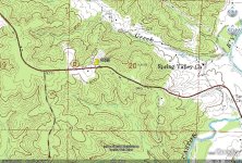
Let's see if this works...a Google Earth over head view of my 50. Taken in the spring of 03 before I owned the place.
It's all oak with some pine, step ridges and draws. The spot near the highway, left side is now a 2.5 acre food plot, I am still working on the other side.
The land behind me on the right is national forest, 350 acres +-.
It's all oak with some pine, step ridges and draws. The spot near the highway, left side is now a 2.5 acre food plot, I am still working on the other side.
The land behind me on the right is national forest, 350 acres +-.
Last edited: