smstonypoint
Super Member
- Joined
- Oct 13, 2009
- Messages
- 5,820
- Location
- SC (Upstate) & NC (Piedmont)
- Tractor
- NH TN 55, Kubota B2320 & RTV 900, Bad Boy Outlaw ZTR
I have two streams on my farm in NC, one of which suffers from bank erosion. In 2013, I applied for NRCS EQIP cost-share assistance in stabilizing 320 feet of the stream. My application was approved and a NRCS engineer designed the project last February.
The NRCS application process was painless, but I did have to obtain a permit from the Army Corps of Engineers (ACOE) before work could begin. That permitting process was relatively painless -- it took me about four hours and a couple of phone calls to the Asheville ACOE field office to complete the permit application form.
I selected a contractor from a list of experienced contractors provided by the NRCS and he began work on the project on September 22. Unfortunately, I was stuck in SC until October 1, and I missed seeing the earth-moving part of the project.
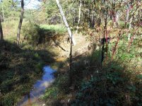
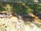
I failed to take any "before" photos, but this shot from downstream illustrates how bad the bank erosion was on one section of the project.

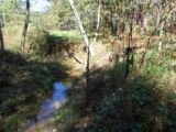
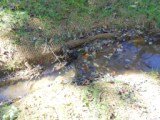
Here's a shot (looking south) of the beginning section of the project.

There was a three-foot drop off to the stream within about three feet of the stream crossing. I felt safe crossing the stream with my RTV 900, but I wasn't about to risk it with my utility tractor. I had the contractor redo the stream crossing outside the EQIP cost-share agreement. He regraded the crossing, and installed geo-textile fabric and three-inch stone.
A bank cave-in (four-foot drop-off) had cost me several loblolly pines from the plantation tract on the right-hand (west) side of the stream.
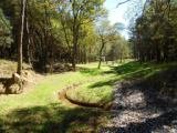
Here's a shot facing north, about 200 feet from the start of the project.

There was about a ten-foot drop-off in the vicinity of the shadow of the walnut tree's top. It would have been just a matter of time before I started losing pines from the plantation tract on the east side of the stream.
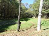
The contractor crew had already installed eight log vanes and three rock vanes in the stream before I arrived on October 1. Apparently, all of the grading and vane installation was carried out under the supervision of the NRCS engineer.
When I arrived, the crew was broadcast seeding rye and fescue. They then installed coconut netting in the floodplain and straw wattles on the banks above the floodplain. They then used a straw blower to cover the banks above the floodplain with wheat straw.
Here are shots of a log vane and a rock vane that also show the coconut netting. The log vanes are hardwood logs (sycamore in this case) that the crew wrapped in a thick plastic.


The contractor will return in December to install live stakes of native trees and bushes on the banks above the floodplain.
I am more than happy with the results of this project. My only regret is that I did not apply for cost-share assistance for stabilization of more of the stream. I have now applied for assistance in stabilizing an additional 2,000 feet. I will hear in February whether my request has been approved.
Steve
The NRCS application process was painless, but I did have to obtain a permit from the Army Corps of Engineers (ACOE) before work could begin. That permitting process was relatively painless -- it took me about four hours and a couple of phone calls to the Asheville ACOE field office to complete the permit application form.
I selected a contractor from a list of experienced contractors provided by the NRCS and he began work on the project on September 22. Unfortunately, I was stuck in SC until October 1, and I missed seeing the earth-moving part of the project.
I failed to take any "before" photos, but this shot from downstream illustrates how bad the bank erosion was on one section of the project.
Here's a shot (looking south) of the beginning section of the project.
There was a three-foot drop off to the stream within about three feet of the stream crossing. I felt safe crossing the stream with my RTV 900, but I wasn't about to risk it with my utility tractor. I had the contractor redo the stream crossing outside the EQIP cost-share agreement. He regraded the crossing, and installed geo-textile fabric and three-inch stone.
A bank cave-in (four-foot drop-off) had cost me several loblolly pines from the plantation tract on the right-hand (west) side of the stream.
Here's a shot facing north, about 200 feet from the start of the project.
There was about a ten-foot drop-off in the vicinity of the shadow of the walnut tree's top. It would have been just a matter of time before I started losing pines from the plantation tract on the east side of the stream.
The contractor crew had already installed eight log vanes and three rock vanes in the stream before I arrived on October 1. Apparently, all of the grading and vane installation was carried out under the supervision of the NRCS engineer.
When I arrived, the crew was broadcast seeding rye and fescue. They then installed coconut netting in the floodplain and straw wattles on the banks above the floodplain. They then used a straw blower to cover the banks above the floodplain with wheat straw.
Here are shots of a log vane and a rock vane that also show the coconut netting. The log vanes are hardwood logs (sycamore in this case) that the crew wrapped in a thick plastic.
The contractor will return in December to install live stakes of native trees and bushes on the banks above the floodplain.
I am more than happy with the results of this project. My only regret is that I did not apply for cost-share assistance for stabilization of more of the stream. I have now applied for assistance in stabilizing an additional 2,000 feet. I will hear in February whether my request has been approved.
Steve
Attachments
Last edited:
")
