".... "mammacumulus clouds" Jay? Is that a real weather term or are you pullin' our leg (again)?"- RNG
I try not to post any more neologisms here, but I still slip up sometimes

. My word memory is starting to fail which probably is a good thing. Actually I was close, and wrong:
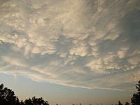
"Cumulus mamma clouds must be distinguished from mammatus clouds. The mammatus cloud formations are very distinct in that the formations look like the udders of a cow or like a woman's breasts. The mammatus clouds tend to look heavy and for some people ominous, whereas the cumulus mamma clouds do not portray that representation. The cumulus mamma clouds appear substantially lighter than the mammatus clouds and tend not to be grouped on a large base. The mammatus clouds usually appear as a large formation of udders that hang from the sky and if coupled with lighting, can provide an interesting and often inspiring visual presentation."- internet source
Actually those clouds were mammatus. Those udders
"... I think the foothills where I live break up the storm fronts enough to stop the cyclonic motion that leads to the tornados."- RNG I agree with you. We just missed the previous MA tornado in Great Barrington. That storm touched down in the river valley, but this tornado did track through the surrounding hills. It took out large tracts of forest.
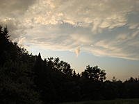
We were traveling up the next parallel river valley on the other side of the hill range. I have never seen weather like I saw that trip before or since. I have seen quite a few cumulus mamma clouds form in the CT River Valley and based on track break up when they run into the surrounding hills. There was a small F1 last year than touched down briefly in one of the nearby hill towns (Conway, MA). The surrounding hills appear to have torn this tornado up.
The NWS uses more strange and crazy words than I
I can not "explain" my fascination with the "strange and crazy." I do have a few "assumptions" :embarrassed: