You are using an out of date browser. It may not display this or other websites correctly.
You should upgrade or use an alternative browser.
You should upgrade or use an alternative browser.
Reading a Surveyors Plot Plan Question
- Thread starter MarkF48
- Start date
- Views: 2072
/ Reading a Surveyors Plot Plan Question
#11
Diggin It
Super Star Member
If that's the case, then the 326 includes the 97.
But really, put the pencil down, grab a long tape measure and go outside.
But really, put the pencil down, grab a long tape measure and go outside.
clemsonfor
Super Member
Or if you can pace. Pace it off your just trying to get close to find a pin right. We're you sure when searching you were in the right spot now?If that's the case, then the 326 includes the 97.
But really, put the pencil down, grab a long tape measure and go outside.
RoyKing
Platinum Member
Nope I was wrong without the azimuth of the property line it can't be determined
Or if you can pace. Pace it off your just trying to get close to find a pin right. We're you sure when searching you were in the right spot now?
Nope, was not searching the correct area where I thought the pin should be, but where it might be now is about the location of where a 3' diameter maple tree was that the town removed about 20 years ago. I have no clue if the pin disappeared or if something else may have happened to it. I'll give another try with the metal detector where I think it might be.
rbtjr
Gold Member
Does the recorded map say that the drawing is to scale? It is sounding like it is not. I assume that the map identifies the surveyor who did the work. Is he still alive or is the surveying company still in business? If so, or if you can find out which current surveyor (if any) inherited the prior surveyor's business, you might get access to file notes that would explain the drawing.
I don't remember ever having seen a surveyor's drawing that showed courses to the minute of a degree (60ths) and the distances to hundredths of a foot and were off so much as this drawing would be if the 326 includes the 97 without a note to that effect. And I am confident that I have never seen on a survey a distance that was the sum of a straight-line distance and an arc distance. Admittedly, the scale that shows up above makes it look like the 326' straight line is not long enough in proportion to the 97', so something is off. What is off is not clear to me.
I don't remember ever having seen a surveyor's drawing that showed courses to the minute of a degree (60ths) and the distances to hundredths of a foot and were off so much as this drawing would be if the 326 includes the 97 without a note to that effect. And I am confident that I have never seen on a survey a distance that was the sum of a straight-line distance and an arc distance. Admittedly, the scale that shows up above makes it look like the 326' straight line is not long enough in proportion to the 97', so something is off. What is off is not clear to me.
Does the recorded map say that the drawing is to scale? It is sounding like it is not. I assume that the map identifies the surveyor who did the work. Is he still alive or is the surveying company still in business? If so, or if you can find out which current surveyor (if any) inherited the prior surveyor's business, you might get access to file notes that would explain the drawing.
I don't remember ever having seen a surveyor's drawing that showed courses to the minute of a degree (60ths) and the distances to hundredths of a foot and were off so much as this drawing would be if the 326 includes the 97 without a note to that effect. And I am confident that I have never seen on a survey a distance that was the sum of a straight-line distance and an arc distance. Admittedly, the scale that shows up above makes it look like the 326' straight line is not long enough in proportion to the 97', so something is off. What is off is not clear to me.
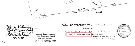
Attached is a fuller screenshot of the drawing (some names and places deleted out). The surveyor evidently was born in 1909 from records I could find of his name, so I suspect he is deceased. I have no knowledge of any survey companies that he may have been affiliated with as this survey had been done by a previous owner. I'm assuming the signatures on the drawing are sign offs as acknowledgements for correctness. The scale is clearly stated and I assume it would be correct for the original drawing.
Attachments
Oldoak
Veteran Member
- Joined
- Feb 20, 2013
- Messages
- 1,817
- Tractor
- Kubota L5060GST, J D X758 GT, J D 855D XUV
Is there a plot map of your neighbor's property recorded in the courthouse? Perhaps you could start measuring from the other side of your neighbors property to where his and your property line join. That should at least narrow down the search area for your missing survey pin.
In many areas, Google maps shows property lines. Switch back and forth between map and satellite view to see where the lines are, if they don't show in satellite view. My corners on Google are within a foot or two of accurate.
This may give you a good idea of where to look for corner pins.
Bruce
This may give you a good idea of where to look for corner pins.
Bruce
