MarkF48
Gold Member
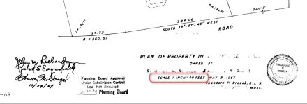
I've been going over some of my old home and property records and I came upon and old plot plan from 1967 just prior to when my wife and I bought the property. The actual property line between me and the neighbor has never been disputed and likely he doesn't know where the property line actually is or even cares. Most of the plot plan is fairly clear to me as straight lines and coordinates, but I'm not sure about the road frontage that includes a radius. There is frontage that is 326.06 ft. which continues as a radius portion of 97.72 ft. I'm not sure if the 326 ft specifies the total frontage and the 97 ft is considered a separate as a dimension for the radius by itself or if the two are added for a total of about 424 ft. The iron pin (I.P.) is not visible above ground where I think it should be and I've searched with a metal detector if it had gotten buried over the years. I did locate the D.H. (drill hole) marker at the opposite end in a large stone. The plot plan was done by a licensed surveyor and registered with the state/county 'Registry of Deeds' so I don't doubt it is correct.
Are these road front footages considered separate or added?
Plot plan section image attached.....

Are these road front footages considered separate or added?
Plot plan section image attached.....
 .
.