Detailed rainfall mapping...

   / Detailed rainfall mapping... #1  

Redbug

Veteran Member
Joined
Aug 9, 2004
Messages
2,118
Location
Columbia, SC
Tractor
Kubota L3830HST
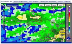
Just how much rain fell at home or the farm? A good rainfall is literally worth millions across the state when in a drought...

[SIZE=+1]To see detailed rainfall amounts...

1. type in your place...such as Bamberg, SC.
2. click states, county, road/town overlay
3. click last 2 days...or whatever...
4. then hit "Go".
5. compare the color to the precip scale.
6. You can also adjust the pcpn opacity scale. This is good if you want to use the satellite or hybrid maps.

You can zoom in, zoom out, pan, etc.

RFC Precipitation Analysis

Pretty neat huh? [/SIZE][SIZE=+1]Bird, Mikim, and Jinman can compare rainfall with the other Texas members...[/SIZE]
 
Last edited:
   / Detailed rainfall mapping... #2  
That is a good page, I have used it before. Accuracy sometimes not the greatest, like the rain yesterday, said we received .10" we had maybe 3 drops.

It is a good general map though
 
   / Detailed rainfall mapping... #3  
Thanks Redbug. I've been looking for something like this for a long time. I have an accurate rain gauge here at home but I like to get an idea of rainfall elsewhere in the state - or country.
 
   / Detailed rainfall mapping...
  • Thread Starter
#4  
Von...(Western?), since you have a rain gauge set up, it would be interesting to see what the differences are. Most of the rainfall on the map is radar derived. I have an accurate rain gauge in the back yard, too.
 
   / Detailed rainfall mapping... #5  
Nice URL, thanks.

We always seems to be right on the boundary edge between two zones ;-)

But it seems fairly accurate. YTD total it shows 25-30", my guage shows 28.40"

Ken
 
   / Detailed rainfall mapping... #6  
Rain:confused: I ain't got no stink'n rain:( Less than 7 inches all year so far....and, it didn't really rain last year either:confused2:
 
   / Detailed rainfall mapping... #7  
Pretty neat huh? [/SIZE][SIZE=+1]Bird, Mikim, and Jinman can compare rainfall with the other Texas members...[/SIZE]

Redbug, that is neat feature of the NOAA/NWS. I've used it before, but not recently. Thanks for the reminder. In my area, the map is very accurate for the last 30 days. Notice the circled area in the attached map. Just south of me near the town of Alvord, they have had 3" of rain in the last 30 days. There is a fellow there who just did his 2nd cutting of hay and his coastal bermuda fields are green and lush, growing like crazy. He's also in a creek bottom that retains moisture. If I were to take a picture of his fields, it would make some of my fellow Texans in central and south Texas very jealous.

I see the map also shows that Western (Dennis) has had very little rainfall in Springtown just as he says. It's amazing the difference just a few miles makes. That's just the nature of summertime rainstorms in Texas.
 

Attachments

  • Rainfall.jpg
    Rainfall.jpg
    106.7 KB · Views: 73
   / Detailed rainfall mapping...
  • Thread Starter
#8  
Here's another good one I like to look at, too. It will show how bad the drought really is...

1. Go to Archive: Select "Month/Yr".
2. Pick your month and year.
3. Select "Departure from Normal".
4. Select "States" and go down and highlight your state.
5. Also, make sure you turn on "Counties, and Hwy/City".

Once your map comes up, you can toggle thru the month and/or year selections and go through time that way. Play around with this one. There's a lot that can be derived from that "product" box and paging thru time. Only bad thing...there is only data back to 2005.

AHPS Precipitation Analysis

Jim...I work for the Weather Service...
 
 
Top