DIY Land Survey

/ DIY Land Survey #1  

HomeBrew2

Banned
Joined
Dec 22, 2004
Messages
1,917
Location
Dunlap, CA
Tractor
Kubota BX23
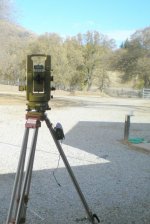
Mostly just for the fun of it, I decided to buy and old Topcon GTS-2B [semi-]total station to check my boundary and do a complete topo so I can build a 3d model in AutoCAD.

This model instrument is pretty old but has EDM (electronic distance measuring) thru the telescope with digital display of slope distance but, the the angles are read optically, like a plain theodolite, via a small scope next to the telescope eyepiece. It's, nominally, a 6" (second) gun, with estimates easily to 2" on the micrometer scale.

Unfortunately, the old Topcon battery pack wouldn't hold a charge so, while I'm working that out with the seller, I cobbled an external battery pack out of an 8-cell AA battery holder, power connector from Radio Shack, and some new whizbang 2400 mAh NiMH batteries. Really like that 15 min charger!

I needed to check how well the old gun was calibrated so, I wrapped up a few horizontal angles with great results. The vertical? Not so good. I had to adjust out about 2' (minutes) of index error. Good to go now. I'm in the process of trying to find a local baseline to check a long distance but, for now, I was able to check the EDM vs a nice Lufkin chrome-clad 100' tape as well as a simple 2-peg test of 400+'. That seemed good too, +/- 0.02'.

I haven't been able to find a decent wooden legged tripod, cheap, so I'm using the aluminum one I got for my DeWalt laser level last year. (Reviewed on TBN previously.)

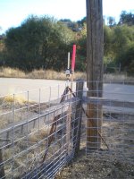
It just so happened that I was able to salvage an old, damaged prism and prism pole from a job in a previous life. It's been in my rafters for a decade or so. Perfectly functional now.

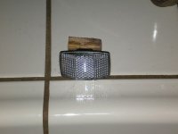
Because I'm working by myself for now, I used an old non-adjustable cheapo wooden tripod to hold the prism pole. It had some orphan head size that fit the pole diameter nicely.

So, that's the field equipment, but ... Seemed like it would be awfuly handy to have a little field computer/data collector. Long story short: I picked up a used PDA with Pocket PC 2003 and totally lucked-out to find TDS (Tripod Data Systems) had a free (not a trial or limited functionality) download of their COGO (coordinate geometry) software for my PDA. Some days I'm just plain lucky!

I got the boundary done Saturday afternoon. The equipment and proceedures worked really well. Good thing I did this before driving a bunch of steel in the ground for re-doing my back fence ... one corner monument was 30' out of position compared to the subdivision map (all others were well within 0.5'). Now I'll have to go search for and investigate adjacent monuments to see what the prob is. Never a dull moment :rolleyes:

Cheers!
 

Attachments

  • PC080029a.jpg
    PC080029a.jpg
    114.8 KB · Views: 2,059
  • PC080031a.jpg
    PC080031a.jpg
    138.2 KB · Views: 1,201
/ DIY Land Survey #2  
i had a topo shot of the "important" part of the property by the RLS my wife works with....

the result

http://www.snjschmidt.com/pics/property/property_topo.jpg

she recut the contours in the puter so i could get a better idea whats going on. (otherwise standard 1' (or 3') contours would have ment like 2 lines being drawn on my 5 acre lot...

the red lines are .5' invervals... the yellow lines are .1' (or roughly an inch)

so ya most of the property is flat with in 6"
 
/ DIY Land Survey #3  
On a related topic..........Here is a website that has satellite photos and topo views, along with a planimeter for calculating acreage / dimensions. The planimeter works pretty good once you mess with it.......


Google Planimeter
 
/ DIY Land Survey
  • Thread Starter
#4  
schmism said:
i had a topo shot of the "important" part of the property by the RLS my wife works with....

just curious, hows comes all the dirt/turf grades on the pic you posted are only plotted to the nearest .01' ? my old gun displays to .001' and my PDA calcs to 15 decimal places. seems like youall could have gotten .05' contours with .2' index contours and gotten a lot more lines to look at :rolleyes:
 
/ DIY Land Survey #5  
What version of Acad are you running. I have a great COGO program for R14.
Is that Topcon (semi)TS called the "Guppy" or was the "Guppy" just after.
 
/ DIY Land Survey #6  
the office uses Acad 05/06 whatever the latest is with geopak

at home we have 2004
 
/ DIY Land Survey #7  
shaley said:
What version of Acad are you running. I have a great COGO program for R14.
Is that Topcon (semi)TS called the "Guppy" or was the "Guppy" just after.

The Guppy came before the GTS 2B.

Bruce
 
/ DIY Land Survey
  • Thread Starter
#8  
shaley said:
What version of Acad are you running. I have a great COGO program for R14 ...

Kindof depends on what I'm doing and where. Mostly 2002 but also LandDesktop 3. I have Map3d 2007 still in box. I think I may have 14 still on an old laptop. Is your cogo a series of lisp routines or an executable that runs inside ACad? Is it shareware/freeware?
 
/ DIY Land Survey
  • Thread Starter
#9  
shaley said:
... Is that Topcon (semi)TS called the "Guppy" or was the "Guppy" just after.

Sorry I'm not a surveying equipment historian but, glad someone chimed in to help you out.
 
/ DIY Land Survey
  • Thread Starter
#10  
I've had offers from some friends to help with my surveying tasks but, one never knows how that will work out, so I'm always looking for ways to do with what I have, by myself.
An old electronic surveying trick is to use an ordinary white/clear bicycle reflector as a "prism" for appropriate distance measurements. ... kindof defeats the purpose of buying way-over-priced "surveying" prisms, etc.
The attached pic of such a bicycle reflector yielded shots of 120'. Darkness and beer preempted longer distance tests today :)
 

Attachments

  • PC120032a.jpg
    PC120032a.jpg
    41.2 KB · Views: 891
/ DIY Land Survey #11  
I got a chance to see just how expensive those fancy prisms were when some hoodlum stole my backsight!! Backsight being the tripod mounted prism on the other monument used to establish your location. The crooks actually released the prism from the tripod and made off with it. I'm sure the kids don't realize how expensive the fancy mirror is in their bedroom. Nomatter where you are when you look at the prism you always see your eye.
 
/ DIY Land Survey
  • Thread Starter
#12  
Highbeam said:
... some hoodlum stole my backsight!! ....

Ouch! Yeh, now that I'm going to have to tramp around the neighborhood tieing out corners, I figured a bike reflector tacked to a plumbed lath would be an expense I could tolerate should it get swiped or runned over.
Also nice to be able to tack up a dozen of em on trees, etc, take a dozen shots, grab a beer, repeat.
 
/ DIY Land Survey #13  
Champy said:
On a related topic..........Here is a website that has satellite photos and topo views, along with a planimeter for calculating acreage / dimensions. The planimeter works pretty good once you mess with it.......


Google Planimeter


Try Google Earth Too! Requires a download but is very cool. I was able to take a scanned survey property map of my 27 acres and then fit it over satelite photos from Google Earth (you can make the map transparent). This allowed me to locate all the corners of my property quite easily. You can also add your own markers and use a ruler to take accurate measurements. It is pretty cool stuff.

Google Earth - Home
 
/ DIY Land Survey
  • Thread Starter
#14  
dillo99 said:
... This allowed me to locate all the corners of my property quite easily. ...

I am a fan of the accessability of land plats and other legal records and aerial photos via the internet, no matter the source. Google "anything" is worth what you pay for it.

I think we may have a slight disconnect between reality and "internet-based surveying" on this particular thread though.

The internet is a wonderful resource for information of all kinds. And many hits from a search provide real, usable info. Copying, pasting, rotating, scaling, is fun ... and has great visual benefit ... but virtually no merit in regards to a legal, court-substantiated boundary.

Just my take on reality as I know it ...
 
/ DIY Land Survey #15  
HomeBrew2 - "The internet is a wonderful resource for information of all kinds. And many hits from a search provide real, usable info. Copying, pasting, rotating, scaling, is fun ... and has great visual benefit ... but virtually no merit in regards to a legal, court-substantiated boundary"

I agree 100% regarding the legality of it. However I was using the online planimeter to estimate the boundary lines of properties for sale that we were considering splitting. Nobody wants to pay $3k for a legal survey just to determine where the north half of a odd shaped 60 acre farm really lies - then find out you really don't want it. I also used it to approximate acreage claims by realtors - and you'd be surprised how far off they were!

I "surveyed" the land we ended up buying via the online method, and kept coming up with 5 acres more than the realtor or the county accessor showed. Guess what - after the formal (legal) $urvey......we had 4.3 more acres! This process won't stand up in legal terms for deeds; etc.. but as a quick and easy means to estimate property lines; acreage; etc.... you can't beat it.
 
/ DIY Land Survey
  • Thread Starter
#16  
Champy said:
... you can't beat it....

I'm with ya man. When it works, it WORKS! And I am glad it worked for you :) Umm, also glad you had it surveyed but sorry it was so much $.
 
/ DIY Land Survey #17  
**When it Works** and sometimes it does. But sometimes it is doesn't.

I used the property lines and aerial photos from Zillow.com along with the contours from Topozone.com to *point* me to my property lines. I was then able to find the actual property markers.

However I also have the legal description to verify that the online stuff is at least close to being correct. I looked at the online property lines for a couple of neighbors and some were right and some were totally wrong.

Zeuspaul
 
/ DIY Land Survey
  • Thread Starter
#18  
zeuspaul said:
**When it Works** and sometimes it does. But sometimes it is doesn't....

This seems like an appropriate time to open the can-o-worms regarding internet "parcels" and such. (Uggg)

Unfortunately, rarely, does anyone notice, or have access to the metadata (specifications about the 'data') for the online parcel data. Most folks assume that because it comes out of a 'puter, it's dead nuts and gospel.
Obviously to some, this is the realm of GIS (geographic information systems). This may be a news flash to some, THERE ARE NO STANDARDS, LAWS, UNIFORMITY OR ANYTHING ELSE THAT QUANTIFIES THE ACCURACY/PRECISION OF THE BOUNDARIES DEPICTED in a real-world-coordinate representation.

Case study: I built and now maintain the GIS in a neighboring county. Unfortunately, the Board of Supervisors funded the data development but, did not fund any field surveying, in any context of the phrase, as a basis for the parcel layer. What we wound up doing was scanning all the Assessor's maps and squishing, squashing, streching and morphing everything to fit inside the individual "sections" (public land survey sections) as they are depicted on USGS quad sheets.

An educated guess as to the accuracy of our parcel data is +/- 20% in the worst case. Best case, 1%. (1%=A city lot with 60' frontage could measure 60.6' or 59.4'.) You do the math on the worst case for a large parcel.

So, my purpose in my little [professional] world is to strongly advertise our "parcel" data as being a really neat graphic index of the 130,000 or so parcels in the county ... with absolutely no realation to real world dimensions to any specific parcel of land.

No, I'm not the least bit happy with this state of affairs of data accuracy but am very aware of the astronomical amount of money it would to take to research, survey (even with GPS), calculate, adjust, and publish accurate parcel data for 4500 square miles of dirt in one of the poorest counties in Kalifornia. And, I'm sure there are jurisdictions a whole lot worse off than the county I work for ... but everybody's website looks cool :cool:

Reference: I have a Bachelor's in Land Surveying and Photogrammetry from Fresno State U, LSIT certificate, 15 years partychief/field engineer, 2 years Chief of Surveys, 11 years GIS.

Cheers!
 
/ DIY Land Survey #19  
Hey guys:

I was wondering if you could do a quick survey or even a topo map of property using consumer gps units? Seems like it should be doiable?

James
 
/ DIY Land Survey
  • Thread Starter
#20  
crocodile_jkg said:
Hey guys:
I was wondering if you could do a quick survey or even a topo map of property using consumer gps units? Seems like it should be doiable?
James

Here's my take on it: If you can walk your driveway, or other simple route, two or three times and get the same results, horizontally, you've got a good chance of making it happen. I couldn't get better than +/-50' among discrete "surveys". Be aware that horizontally, [consumer] GPS, is, or has the possibility of being, fairly accurate but, vertically it is pretty hard to get reliable results ... the satellite geometry is just wrong and usually results in poor solutions.
 

Marketplace Items

2019 Jeep Grand Cherokee SUV (A59231)
2019 Jeep Grand...
HYDRAULIC TILTING BUCKET FOR MINI EXCAVATOR (A58214)
HYDRAULIC TILTING...
2021 UTILITY VS2DX 53FT DRY VAN (A59905)
2021 UTILITY VS2DX...
YANMAR VIO35-6A EXCAVATOR (A59823)
YANMAR VIO35-6A...
2019 LGMG SS1932E ELECTRIC SCISSOR LIFT (A60429)
2019 LGMG SS1932E...
UNUSED FUTURE FT50-(50) 12' PIECES OF GALVALUME (A60432)
UNUSED FUTURE...
 
Top