Alien
Elite Member
My drone arrived OK. Did all the upgrades and calibrations and had a brief fly around before dark. Working great. Update after I do some movies etc.
My drone arrived OK. Did all the upgrades and calibrations and had a brief fly around before dark. Working great. Update after I do some movies etc.
I have a feeling that drones are gonna get hard to buy, cell phones too.

Why would that be?
Well I think that there are plenty of unboxing videos on youtube already. Personally I dislike unboxing vids. LOL If you want to see some videos you need to type in FIMI X8 SE 2020
There are a number of non 2020 videos but that is the older version of the 2020 drone.
This fellow doesn't stop talking but it is an interesting video where he checks the range. Nice country. Long Range Fimi X8 Se 22 Brasil | Sera que chegou a 8 Km ou foi mais que 8 Km - YouTube
There are a few more as well. I will do some pics later. Only 5.30a.m. here and still dark.
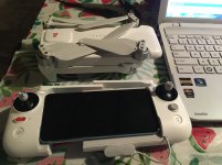
View attachment 666122
Because the Chinese are tightening up on chipsets. 99% of drones come from China or some Oriental country. Only Parrot (that I know of isn't) and Parrot is done in the consumer market.
Well I think that there are plenty of unboxing videos on youtube already. Personally I dislike unboxing vids. LOL If you want to see some videos you need to type in FIMI X8 SE 2020
There are a number of non 2020 videos but that is the older version of the 2020 drone.
This fellow doesn't stop talking but it is an interesting video where he checks the range. Nice country. Long Range Fimi X8 Se 22 Brasil | Sera que chegou a 8 Km ou foi mais que 8 Km - YouTube
There are a few more as well. I will do some pics later. Only 5.30a.m. here and still dark.
Interesting. And surprising.
Rob
I'm looking for my first drone for two prime purposes, both in remote northeast Mississippi.
1. Monitor my rooftops - I've 7 good sized roofs mostly not visible from the ground or adjacent buildings. All surrounded by trees which drop limbs, needles, leaves etc. BUT provide a lot of shade. I'd like to be able to get a view of the tops after storms versus getting the ladder out. So that purpose could be served easily by a small limited drone.
2. Monitor my "lots", I've 7 parcels of land that have road frontage and are over 25 acres each. I'd like to be able to look at who is clearing timber on my lots. Most lots the roads run on the ridges so if I can get up a few hundred feet I should be able to see the entire lot.
I've had one guy that cleared 1/2 acre of prime 10 yr old planted pine to set up a landing so he could haul trees out from his lots. Never asked, I discovered it on Google Earth about a year later. I think this usage might require more drone power.
So any recommendations for my first drone? (As inexpensive as possible)
Alien,
Where did you buy your Fimi from?