OP
MotorSeven
Elite Member
Spiker, sounds like it's time to sell & move. Unfortunatly it's getting bad all over this country, so choices are limited.
RD
RD
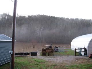
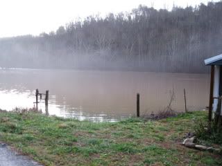
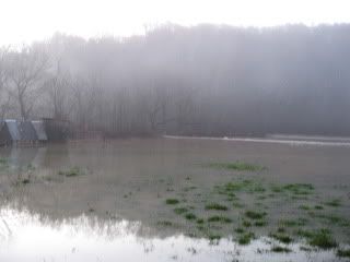
a few years back the big flood due to heavy rains and February thaw the army core of engineers closed the dry dam a few miles down stream from my farm the river flooded everyone out and then froze solid!, it was end of march before a lot of people could even get back to see what kind of damage had happened.... I had lost 1/2 the ways into my place from the north & east I could still access the place luckily. lots had no way in/out. There were 4 or 5 major roads covered with frozen solid ice 3' or more thick... they stopped backing it up when it started breaching US30 side banks and was starting to actually get on the road surface. They backed the water up to its highest level since the dry flood control dam had been built back in 40's. they said it was to keep the people down stream from getting flooded!? They have also added a TAX onto OUR PROPERTIES up stream to pay for the flooding of people down stream??? and to pay to keep the stream/rivers clear and dry dam in operation!?!?! basically we have to pay for them to flood our place to keep the people down stream who built in the flood plane to not get flooded out so bad... go figure...
only the government can tax you for flooding that happens down river from where you live to pay to rebuild peoples homes that built in a flood plane.
Mark
 That's a really incredible story of gov't stupidity. I have no sympathy for people who build on flood plains. I doubt if their flood plain insurance premiums cover their losses, so we all get to subsidize their claims with tax dollars. once I hit the flat bottom that is where the watershed flood plane from the dry dam starts... The road (CR175) had ice over it right next to NEW SR 30, ice was probably 3~4 feet thick there, on south side of US 30 the road (175) had closer to 6 feet I was told... SR42 between Ashland and Mansfield also had 2~3' of ice and was closed for weeks it was a trip watching the state try & clear the ice they had pics on news. Actually we are all on high ground so we are all safe. The lake I drive over was so low back at the end of October you could see the creek beds that are usually underwater. Right now the lake is over what is usually islands and well into the woods on the shore line.
I think they are calling it the "Mohican water shed tax" or something similar. anyone who has/owns property in north center of Ohio who has property that flows SOUTH and EAST has to pay this extra tax. My property does not flood (if it did it would be end of world type thing as I have within 150' vertical highest point of ohio.) Highest point is some 15 miles away as crow flys, but 25 road miles. When I crest the hill at my neighbors property you can see easy 100 miles in the south east direction. and local hills similar to the one I live on in distance but trees cover the sight line to the highest points in Wayne/Median/Loraine county's. That is why I had access in 2 directions to my place access from the up hill sides...
I can coast in the car a good 3 miles once I crest the top...
Mark
I grew up in Lodi, and lived in West Salem, worked @ fritolay next to the Rexroth plant which closed (rexroth closed that is.) I drove past Silver rd all the time..It's a small world. I used to take 302 towards Wooster to visit my in-laws when we lived in Fremont. They lived up off Silver Rd. on the west side of Wooster not far from 250. My FIL worked many years at the Borg Warner/Rexroth plant. Been through Ashland many a time on 250 also. Jeromesville kept sounding familiar so I had to look it up. My wife grew up south of Millersburg in Clark. Her parents moved up to Wooster in the mid-70's since they both worked there.
That's pretty country along Rt. 302.
Dave.
