Question about land surveying

   / Question about land surveying #1  

NCDeere

Bronze Member
Joined
Oct 7, 2004
Messages
56
Location
North Carolina
Tractor
John Deere 4510
Hello everyone. I recently found some land that my wife and kids and I really like. We are waiting on the surveyor to come. I told him that I would cut a line of sight for him on two of the lines. I have found the pins on the corners. Two of them run through some fairly thick forrest. The line is only 450 feet long. My question is how can I know that I am going in a straight line from one point to the other without getting off course? I do have a handheld GPS. I am sure that I can use that to help but am not sure how.

I know the shortest distance between two points is a straight line, but I don't know the easiest way to get there.

Any help would be appreciated.

Thanks,

Bryan
 
   / Question about land surveying #2  
</font><font color="blue" class="small">( Two of them run through some fairly thick forrest. The line is only 450 feet long. )</font> Are there more lines than just one, that is 450 ft long? /forums/images/graemlins/confused.gif
Do you own the land already? /forums/images/graemlins/confused.gif

How worried are you about cutting your 'line' on your neighbors land?
Once the line is cut open, will you be able to see from one end to the other?

Do you know how to use a transit? easiest if you do.
Do you have a compass? a good one will point the way.
Do you know how to use three sticks to run a straight line? doable if you do.

What will the surveyor need to do (other than charge you) if you open up the line for him? (actually the surveyor may run an offset line and then just run the angles to close on the end stake).
 
   / Question about land surveying #3  
There's no need to clear a line of site. I worked for my FIL who was a civil engineer. We did many surveys through the woods and while we might have had to clear some brush out of the way, if there was anything large in the way, as beenthere mentioned, we just ran an offset. If you want to help, be there with a brushhook when he arrives. He will tell you what, if anything, needs cleared away.
 
   / Question about land surveying #4  
What you want is a trueline survey. He will put stakes on the line and in Alabama paint on trees on either side of the line or just on your side of the line. With the neighbors permission you could remove all trees on the line leaving a clear line from corner to corner with stakes every-so-often. I would want stakes about 100' apart so I could see from one to another.

Your GPS will not give enough accuracy for surveying. all it will get is about 6-20' accuracy even with WAAS.
 
   / Question about land surveying #5  
NCDeere,

I assume you already have a plot that shows the bearing and distances...

Get a compass. One you can site a line through. Start at one pin and start working your way down the bearing line to the other pin. Put up flagging tape every once in awhile. When you get to the other side you will see how far you are from the other pin. /forums/images/graemlins/grin.gif

Start from the other pin and repeat the process with the flagging. HOPEFULLY your two lines will meet. You can start clearing so that you hopefully can see from one pin to another.

I have done this with some success. But it takes time. Lots of time. My dad and I have done this on one lot line and we still don't have the line to cross. The "woods" are very very thick and in some places you can't see more then 15 feet. The line is roughly 750 feet long.

The surveyors will be out in a couple of weeks. /forums/images/graemlins/grin.gif

They are charging $99 per hour to run the line and put in stakes.

When they came to do this for a couple of lines I wanted marked they had a crew of four men and to run roughly 1500 feet of boundry took them a good day to do.

Later,
Dan
 
   / Question about land surveying #6  
I bought an elcheapo laser level for $4.98 at TSC a few weeks ago that will shoot 450 ft in low light conditions, ie just after sunset.
Ben
 
   / Question about land surveying #7  
Bryan,

I don't know what kind of GPSr unit you have, but I have done exactly what you're describing, using my Magellan Meridian.

First - load in the coordinates of the back pin by going to the pin and letting the GPSr zero in as much as possible (maybe 10 minutes) and recording the point.

Second - go to the front pin and repeat the process. While you are waiting for the GPSr to settle on the point, change the map display to show a line from your beginning point to the destination point, and zoom in all the way.

Third - while standing on the front pin, set your GoTo destination as the back pin and start walking. Watch the map on the GPSr and try to stay as close as possible to the line drawn from the starting point to the destination. You will have to walk very slowly and mark your line with tape or paint as you go. You may want to repeat this process starting at the back and walking to the front.

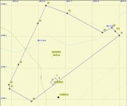
As I said, I used this method to check a 2100 foot line and was accurate to within about 10' all along the line. My next door neighbor had put up a peach orchard, complete with 8' fence and irrigation, and I thought it might be partially on my property. My GPSr method indicated that it was ALL on my property (see attachment) /forums/images/graemlins/shocked.gif.

My neighbor hired a surveyor to disprove my contention, but the surveyor confirmed that I now had a peach orchard, and the actual line was within 5' of the one I had estimated at the point it passed the orchard. My neighbor offered to remove everything, but instead I am leasing it to him for a basket of peaches and berries every year.

The point of my story is that it is possible to get very good readings with a GPSr, if you take your time and know how to use it - and are aware of its limitations. Some factors will negatively impact accuracy, especially dense tree cover.
 

Attachments

  • 705747-Map with orchard.jpg
    705747-Map with orchard.jpg
    46.2 KB · Views: 319
   / Question about land surveying
  • Thread Starter
#8  
Hey guys. Thanks for the advice. I am going to give it a whirl and see how I come out. I am going to see what the GPS will do for me and hopefully I'll come as close as BillG_in_TX did.

Thanks again for the input.

Bryan
 
   / Question about land surveying #9  
<font color="blue"> ( My neighbor offered to remove everything, but instead I am leasing it to him for a basket of peaches and berries every year.) </font>

Get that peach and berry lease in writing, or he -- or his successors -- may be able to claim your land by adverse possession in a few years.
 
   / Question about land surveying #10  
Thanks for the advice. It is in writing, with the above attachment as Exhibit 1. /forums/images/graemlins/grin.gif

The only problem is that the raccoons are doing all the peach harvesting. I was up there this past weekend and my neighbor told me that he is ready to give up on the project. It seems that when the peaches are about 1 week from being ready to pick, the raccoons descend on the orchard. He has tried electric fencing - they either go over or through or under the bottom. He put his three dogs in the enclosure and that didn't slow them down, but the dogs did make a racket. He went over and dispatched 6-8 of them one evening with his varmint gun, but it seemed that more took their place.

Or maybe he just making up this story because he doesn't want to make the lease payment. /forums/images/graemlins/wink.gif /forums/images/graemlins/grin.gif
 

Tractor & Equipment Auctions

Towable Orchard Sprayer (A51691)
Towable Orchard...
2025 New/Unused LandHonor Leaf Blower (A51573)
2025 New/Unused...
1990 JOHN DEERE 544E WHEEL LOADER (A52472)
1990 JOHN DEERE...
378698 (A51573)
378698 (A51573)
4K SAND SEPARATOR (A52472)
4K SAND SEPARATOR...
40' CONTAINER (A51244)
 
Top