Bryan,
I don't know what kind of GPSr unit you have, but I have done exactly what you're describing, using my Magellan Meridian.
First - load in the coordinates of the back pin by going to the pin and letting the GPSr zero in as much as possible (maybe 10 minutes) and recording the point.
Second - go to the front pin and repeat the process. While you are waiting for the GPSr to settle on the point, change the map display to show a line from your beginning point to the destination point, and zoom in all the way.
Third - while standing on the front pin, set your GoTo destination as the back pin and start walking. Watch the map on the GPSr and try to stay as close as possible to the line drawn from the starting point to the destination. You will have to walk very slowly and mark your line with tape or paint as you go. You may want to repeat this process starting at the back and walking to the front.
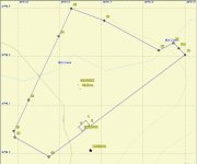
As I said, I used this method to check a 2100 foot line and was accurate to within about 10' all along the line. My next door neighbor had put up a peach orchard, complete with 8' fence and irrigation, and I thought it might be partially on my property. My GPSr method indicated that it was ALL on my property (see attachment) /forums/images/graemlins/shocked.gif.
My neighbor hired a surveyor to disprove my contention, but the surveyor confirmed that I now had a peach orchard, and the actual line was within 5' of the one I had estimated at the point it passed the orchard. My neighbor offered to remove everything, but instead I am leasing it to him for a basket of peaches and berries every year.
The point of my story is that it is possible to get very good readings with a GPSr, if you take your time and know how to use it - and are aware of its limitations. Some factors will negatively impact accuracy, especially dense tree cover.

