Also in Western Washington, last land southward to be glacier covered recently (14,000 years is recent geologically).
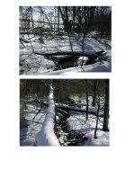
We have a creek running through our property that is one fork of a similar creek. If you follow it upland it ends in tiny puddles that you can connect with your foot to make them"run". If you follow it downstream, it spreads out and disappears. In winter at times you could take a canoe down our creek, 2 24" culverts running fullbore. Same with the other fork. We have hard pan 2-6 feet down. Just like a bathtub. The rain fills the tub and eventually the water table is at the surface uphill, it runs into the creek, then travels downslope until it has found a gravel vein. From their it runs underground for about 1 mile and reappears.
When it is really moving you can go down to where it goes into the ground. (you can't see actually where, prarie grass). There is an incredible sound. Open a can of carbonated pop, pour it into a glass fast and then put your ear to the top of the glass, that is what it sounds like only LOUD.
Idiot County has allowed 100+ home development on postage stamp lots, all of the old farts are hoping the gravel vein will plug up, the development will then be a nice lake.
I read somewhere that below ground there is something like 100 times the amount in all of the rivers and streams above ground, not counting the actual fairly stationery acquifers themselves. Acquifers they consider bodies of water moving very slowly.
Certainly makes sense to me to put 100 houses in a gravel area, with 100 septic tanks over an OBVIOUS TO ANYONE water transport system.
Other developments have later been "saved" by million dollar pumping systems when the county can't figure out why clearing 100's of acres over hardpan in low areas and stuffing houses in causes problems. You'd think they'd learn. Nice to see my property taxes going to good uses.
We have to vote ourselves taxes for schools and paramedic equipment, would be nice if we could vote on the idiotic things instead.