The Lincoln Highway

   / The Lincoln Highway #11  
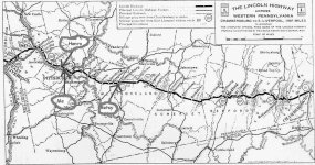
Attached is a map of the Lincoln Highway through Western Pennsylvania.

My wife, Betsy, is from Greensburg, PA, where the Lincoln Highway, US 30, passes right through the center of it. I lived there for a couple of years, about 2 blocks from the route. It wasn't a highway going through town, just a couple of city streets -- one way each, East and West. Her Dad owned a building right on the corner of Main Street and US 30, with about 5 feet of sidewalk between his building and the street. Can't get much closer...

Just West of Pittsburgh, the Lincoln Highway ran along what we called the Ohio River Boulevard, currently PA Rt. 65. It ran through the borough of Bellevue, where I lived until I was 21 years old. I lived about one block North.

A little further West, it passes very near to where Henro lives, now.

{Edit}
A little more research indicates that the Ohio River Boulevard wasn't constructed until 1926-1928. However, the attached map shows the Lincoln Highway clearly passing through Bellevue. I recall that the main street in Bellevue was named Lincoln Avenue, and it's possible that the Lincoln Highway actually ran on the road until the Ohio River Blvd. was constructed.

Most accounts of the Lincoln Highway state it ran on US Rt 30 through all of Penna., but the numbered routes weren't used when the Lincoln was first designated. US 30 runs on the South side of the Ohio River West of Pittsburgh; it's possible that the route of the Lincoln Highway was shifted after the Route numbering designations took place. But, the original Lincoln Highway clearly ran through Bellevue, Avalon, Ben Avon and Emsworth, on down to Sewickley and Ambridge, on the North shore of the Ohio River.

Fascinating stuff for history buffs.
 

Attachments

  • 438882-lincolnhighway.jpg
    438882-lincolnhighway.jpg
    83.9 KB · Views: 122
   / The Lincoln Highway #12  
Gary, in looking at 1924 maps of the Lincoln Highway, I see that it passed through Ligonier, IN about 37 miles West of Fort Wayne. If you look at the map I attached above, you'll see that it also passed through Ligonier, PA (the home of Arnold Palmer), about 50 miles East of Pittsburgh. Think of the early travelers along the highway, who might have taken several days to get from Pennsylvania to Indiana, only to find themselves still in Ligonier!

Ligonier, PA was named in 1758 for the commander-in-chief of the British Army, Field Marshal Lord John Ligonier. Ligonier, IN was named for Ligonier, PA -- apparently, some of the Penna, residents moved West, and wanted a familiar name.
 
   / The Lincoln Highway #13  
It's interesting to note that many of the old major U.S. roads were originally designated by names, rather than numbers.

U.S. Route 30 was the Lincoln Highway
U.S. Route 40 was the National Road
U.S. Route 50-- wasn't it the Northwest Highway, or something similar?

U.S. 22 is another interesting route to take, that we've taken several times from Steubenville to Altoona. I'm not sure if that one had a name at one time or not. I've got an old atlas from 1898 that has names for all of the roads, but I'd have to find it. I'm sure those "highways" at that time were mainly dirt roads (some brick in the cities), travelled by horse and buggies and stagecoaches.

At U.S. 30 and Ohio route 9 in Hanoverton, there's one of the big "L" markers (similar to the Lincoln Highway logo at the top of Don's map) for the Lincoln Highway. To the west, in Massillon, the major east-west road through town is still Lincolnway East and Lincolnway West, even though U.S. 30 is now a four lane highway a couple miles to the south.

If you take OLD U.S. 40 (the part that hasn't been replaced by interstate 70), between Cambridge and Wheeling, you'll run into the old stone milestones every once in a while on the old National Road.

Even though it was never finished, this fellow did an excellent job describing the evolution of each numbered route in Ohio through the years. There's also some good links there too...
"Unofficial" Ohio State Highways Web Site
 
   / The Lincoln Highway #14  
<font color="red"> My wife, Betsy, is from Greensburg, PA </font>

Don, I think some of the folks from there migrated to Greensburg, Indiana. I believe I read that somewhere.
 

Attachments

  • 438940-courthouse_tree_flag.jpg
    438940-courthouse_tree_flag.jpg
    33 KB · Views: 96
   / The Lincoln Highway #15  
Greensburg and Ligonier are both on the Western slope of the Allegheny Mountains. At one time, it was the Western frontier -- folks crossed the mountains to get a little privacy. I guess they were a lot like many TBN'ers -- when it started getting crowded, they kept moving West. Wouldn't surprise me to find a Ligonier and a Greensburg several more times in ever-more-Westward states...

The first Greensburg was named for General Nathanael Greene. Those early settlers really liked their military leaders...
 
   / The Lincoln Highway
  • Thread Starter
#16  
Don,

There is a sign upon enterinig Ligonier, Indiana which welcomes visitors to Ligonier, "A Historic Jewish Community."

I wondered if you knew if Ligonier, PA had a similar history or if possibly it was only members of the Jewish community in Ligonier, PA which came west to Indiana.
 
   / The Lincoln Highway #17  
Ah, I got ya on this one /forums/images/graemlins/smile.gif Shingle Springs was named for the Shingles they used to produce here, and the artesian springs that are around here. Up in to the '70's they used to have a little community fair and one of the things they did was a shingle splitting competition.

We though, are not near any interesting highway. Old H-50 and new H-50 are right here, but do not have much history.

When I was a kid we used to take Sierra College up to Rocklin and zip up old-40 to Ophir. Our old Ford GP/MB with 5.38's and flathead-4 didn't like highway speeds on I-80 /forums/images/graemlins/shocked.gif
 
   / The Lincoln Highway #18  
There is a great tape (or CD) available that starts at Newcastle and makes it's way up to Tahoe explaining all the things along the I80 route that had to do with the Pioneers. You can still see where the wagons wore grooves into the granite up near Donner summit. It's interesting to understand why towns like Dutch Flat, Cisco Grove, Emmigrant Gap, Nyack etc' got their names. It's fascinating too from the perspective of just how tough it was for these pioneers to get over the summit. They had to pull their wagons up in pieces over the granite bolders.
 
   / The Lincoln Highway #19  
<font color="blue">I wondered if you knew if Ligonier, PA had a similar history or if possibly it was only members of the Jewish community in Ligonier, PA which came west to Indiana. </font>

Interesting question. The answer probably lies in a book called The Jews of Ligonier: an American experience by Lois Fields Schwartz. Fort Wayne, IN, Jewish Historical Society, 1978. I found several references to it, but the text is apparently not on the 'Net.

Ligonier, PA sprung from Fort Ligonier in 1758. The earliest history of Jews in that town that I could find was around 1850, so it wasn't a historical Jewish town like Ligonier, IN. It's possible that Jews from PA migrated and formed the new town in IN; but I think the town was already there, and already named Ligonier, when the first Jews arrived in what I believe was 1854. See this link: Jews in Ligonier.

Ah. I just found an answer. Here's a quote from the Noble County Answer Book, published by the News-Sun:

"The city of Ligonier was founded in 1835 by Isaac Cavin, who built a settlement along the banks of the Elkhart River, in an area known as Strawberry Valley. He named the town after his hometown of Ligonier, Pa.

"The town experienced slow growth until the railroad was constructed in 1852. At about the same time, Solomon Mier and Jacob Strauss, two Jewish immigrants, settled in the area and other Jewish people began to follow. Between 1852 and 1866 the town’s population grew from 50 to 1,100.

"Following the Civil War, the town thrived and dozens of new businesses were opened. Mier and Strauss each owned banks, and had some of the largest real estate holdings in the Midwest. By 1900, about 10 percent of Ligonier’s 2,000 inhabitants were Jewish, and the town was known as 'Little Jerusalem.'

"The second generation of Jewish settlers, however, looked to larger cities and by 1940, most of the Jewish influence was gone. Like many small towns, Ligonier waned in the new era of easy transportation following World War II."
 
   / The Lincoln Highway #20  
We still have Lincolnway East and Lincolnway West in South Bend. I have driven on LWW every weekday, twice a day for the last 17 years. /forums/images/graemlins/grin.gif
 

Tractor & Equipment Auctions

2014 FORD F250 XL SUPER DUTY CREW CAB TRUCK (A51406)
2014 FORD F250 XL...
2023 HarbinGer V3 Plus 8KW S/A Towable Light Tower (A52377)
2023 HarbinGer V3...
2025 78in Rock Bucket Skid Steer Attachment (A53421)
2025 78in Rock...
2005 Dodge Caravan Van (A51694)
2005 Dodge Caravan...
2018 FREIGHTLINER CASCADIA TANDEM AXLE SLEEPER (A54313)
2018 FREIGHTLINER...
2000 Ford F-550 Altec AT35-G 35ft Bucket Truck (A53422)
2000 Ford F-550...
 
Top