woodlandfarms said:
That is interesting... I know of Live and Google, and in our area the county photographs once every 2 years to see if you are breaking any building / land laws (they say something different we all know the truth).
Google must be 2002. Microsoft Live is around 2006 (fall) and The county is 2007... Basically just pushing back the blackberries. Looks better in person than in these pictures...
Try installing the Microsoft Virtual Earth Beta from the Microsoft live site -- click the 3D button on the menu (near left, top) and it will prompt you to install it. It's the most amazing thing I've seen -- I'd taken previous "virtual tours" of the Grand Canyon and such -- but this thing has been expanded greatly.
It's the most amazing thing I've yet to see on the internet!
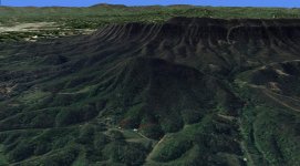
It takes real satellite imagery (the views from Microsoft Live maps) and wraps it as a skin on 3-D topo models of whatever street address you give it. You can tilt, pan, zoom, spin, etc. This is stuff that military flight simulators were doing 10 years ago, costing millions of dollars, and here it is free on the web... It will even let you build 3D models (similar to Google's SketchUp, though simpler) and add them to this 3D view of the world. Amazing stuff!
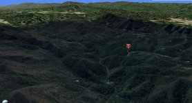
To give you an idea of what it can do, I'm going to post two large screen grabs of the images it generates...
The first is the view of my lot in Tennessee, taken from the vantage point of the top of Chilhowee Mountain, the front range of the Smokies. The pushpin is the clearing on my lot. The high point on the horizon is Clingman's Dome at 6600ft plus, and other high ridge to the left of that is Mt Leconte and Mt Guyot, overlooking Gatlinburg and Pigeon Forge. The state border with North Carolina runs down that spine of the Smokies on the horizon.
The second is a view of of the "family farm" that I grew up on in Tennessee and that my oldest brother still owns. The arrow on the left is pointing toward the farmhouse, and the one on the right points to the barn. The farm includes most of the face of the little mountain just behind it. The steep mountain just behind that one is the north end of Chilhowee Mountain -- the same range that the other view above was taken from. My lot is behind that range, about 15-20 miles further soutn. The Great Smoky Mountains National Park is in the background. Mt LeConte, overlooking Gatlinburg and Pigeon Forge is more prominent on the left in the background.
") And it appears to be only one year old.
And it appears to be only one year old.