Chris616
Silver Member
Thanks, I was wondering if there were some way you could tell me how many feet above sea level this USGS -- Groundwater Watch area of this well might be so that maybe I could use that number and then use how many feet above sea level my property might be and then maybe I could have a guestimate as to how many feet below the surface I might have groundwater.
I hope that makes sense?
This rainbow springs well is quite a few miles from my property but I do not know any other reference to use to get an idea of groundwater levels for my property
Do you have a better idea?
Im also wondering if you have any idea of where I might find something that tell me how far the sand goes down, whats below that and then below that. Do charts like this exist?
I have contacted the local extension services but havent heard back from anyone about this.
USGS -- Groundwater Watch
Yes, the Rainbow Springs well is far enough away that it might not be applicable to drilling on your property, Jason.
Mark's idea of checking for a state database of drilled private wells seemed more promising. Here's the link that you need if you want to do more looking around:
http://www21.swfwmd.state.fl.us/maps/pages/viewer_wcp.html
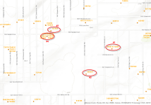
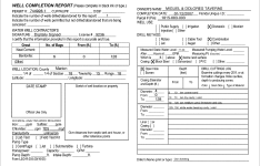
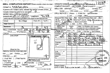
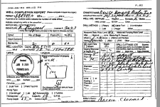
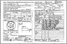
Since I was in there anyway I saved the well completion logs from four wells surrounding your property. All within half a mile. The "Measured Static Water Level" ranges from 40 feet to 71 feet.
Chris

 1 RAINBOW SPRINGS WELL NEAR DUNNELLON, FL