Clearing land for my building and yes more math problems

   / Clearing land for my building and yes more math problems #31  
Where would I find a synopsis of the steps I should consider when it comes to land clearing for a new home.

Example: the land isnt stupid sloped but there is some slope, ........I dont understand or know if that has to be corrected before building? Maybe they just sink the rear portion of the foundation a little further in the ground so that the front of the foundation balances out?

Maybe I need to consider that instead material has to be brought in so that the land is leveled ( or relatively level to allow drainage )

If material is brought in than what material is that......my current soil is sand mixed with sand and then topped of with more sand....so would the same sand be used?

Ive been told that once I have completely cleared the land someone with a root rake or a grapple with a larger tractor than I have has to clear the earth of all roots, I understand why this might be done assuming this is the case but if the land has to be filled anyway than does the roots have to be cleared anyway?

Ive pushed alot of Oak trees over, theres a big ball at the bottom but I know there are a ton of roots still left in the soil.


Slope is a good thing imo on a build site. I wish it was code down here that if no natural slope that build sites would have to be built up to allow for good drainage.
On my property at my build site I have built it up and it has a 18" fall from build site to the 100 ft out mark. The quicker you get the water away the better.

As far as material brought in. Contact a local contractor and see what they recommend and have to offer. Mixes of dirt have different compaction rates. Some will compress and hold and some will always be loose. Paving contractors for state hiways, interstates etc do soil compaction tests to tell what kinda fill material it is.
 
   / Clearing land for my building and yes more math problems
  • Thread Starter
#32  
Thanks for the info
 
   / Clearing land for my building and yes more math problems
  • Thread Starter
#33  
I had a bit of time to poke around before dinner...

Jason - your county has an online tool that is easy to use (it's the same one used where I live). There is some information there that might be useful to you in your planning (property boundaries, zoning, etc.) . If you can figure out how to take pictures on your phone/camera and upload them as attachments to a post on TBN you're computer literate enough to use it :)
Geocortex Viewer for HTML5

Here's the latest aerial/satellite photography of your property from 2017 overlaid with the land contours (labels in feet). So you can see a 16 foot elevation difference between the northwest corner and southeast corners of your property. Not much else to see in the aerial view except trees.
View attachment 613710

It used to be that if a property was shielded from the road by trees or something else that people couldn't really know what you were up to. That has all changed with detailed aerial/satellite photography available to everyone, including the folks setting our property taxes. Forget putting up a building without a permit - the view of our property is so detailed I can see the BBQ on the back deck of our house.

Chris

Is it possible for you to explain to me how to use some of the features on the Marion County GIS deal.

If I click on the link you have provided here and wait for it to load and then go to upper right hand corner and click on parcel search and enter my parcel id number 17325-015-00 it will bring me to my property.

Id like to start out with understanding how you could see the elevation figures you came up with, are you able to explain this too me?

Ive been on this site many times and played around but Im just not seeing much that Im understanding.

Geocortex Viewer for HTML5
 
   / Clearing land for my building and yes more math problems
  • Thread Starter
#35  
Ive measured distances already on the map, I can measure all the boundries and see they are close to what survey says. Thats about as far as Ive been able to go
 
   / Clearing land for my building and yes more math problems #36  
On the county site, after finding your parcel and clicking Map It, select the Mapping link in the upper right section. Then select Layer Control, and check any layers you want to add and finally select Update Map at the bottom of the layer list.
The numbers in the contour map represent actual elevation. The one he attached has more detailed elevations, but it aligns with the elevations on the county site which only shows 10' increments.
 
   / Clearing land for my building and yes more math problems #37  
I also struggle with sites like these. If your patience is strong they can be learned. Then the benefits are pretty amazing.
 
   / Clearing land for my building and yes more math problems
  • Thread Starter
#38  
On the county site, after finding your parcel and clicking Map It, select the Mapping link in the upper right section. Then select Layer Control, and check any layers you want to add and finally select Update Map at the bottom of the layer list.
The numbers in the contour map represent actual elevation. The one he attached has more detailed elevations, but it aligns with the elevations on the county site which only shows 10' increments.
Thanks, Ill try like you say
I also struggle with sites like these. If your patience is strong they can be learned. Then the benefits are pretty amazing.
Im not really a comp person. Id rather be doing things with my hands
 
   / Clearing land for my building and yes more math problems #39  
Is it possible for you to explain to me how to use some of the features on the Marion County GIS deal.

If I click on the link you have provided here and wait for it to load and then go to upper right hand corner and click on parcel search and enter my parcel id number 17325-015-00 it will bring me to my property.

Id like to start out with understanding how you could see the elevation figures you came up with, are you able to explain this too me?

Ive been on this site many times and played around but Im just not seeing much that Im understanding.

Geocortex Viewer for HTML5

Sorry for the delay, Jason. TBN didn't give me any notification that your discussion thread was still active.

Mark's response (post #36) left out a few details, so here are the steps in great detail:
- Click the link to the Marion County GIS viewer.
- After it finishes loading, click "Parcel Search" in the "Basic Tools" menu.
- Input your parcel ID into the rectangle and click the "Search" button.
- After it finishes loading, at the bottom-left of the screen click the tab heading labelled "Layers".
- Click the plus sign to the left of "Elevation Information" to open up a sub-menu.
- In that sub-menu, click to select the checkboxes next to "Contour Labels (1 ft)" and "Contours (1 ft)".
- If you want to also see the satellite/aerial photos like in the picture that I uploaded, then in the same list where you found "Elevation Information" scroll down and click the plus sign next to "Aerial Imagery".
- In the sub-menu that opens up, click to select the checkbox next to "Aerials 2017".

By zooming in and out (making the magnification bigger or smaller), you should be able to get the exact picture that I got (except that I blanked out your parcel ID and another identifier so that I didn't give out any information that you had not already done). You can do that using the plus/minus signs at the top left of the image.

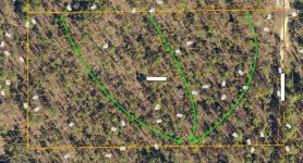
A contour map shows lines of constant elevation. If you walk along any of the lines you're not gaining or losing elevation. The numbers indicate height above some reference level. I'm guessing that in Florida that the "122" at the top-left of the image (north-west corner) means 122 feet above sea level. The reference elevation doesn't really matter, though. You're just interested in the difference between the numbers on your property. I see "122" in the north-west corner and "104" along the southern border (near the centre east to west).

Since the contour lines shows constant elevation, drawing a line that is perpendicular to the contour line shows "straight downhill" or "straight uphill" depending which way you're looking. In the following picture I've drawn three lines that go roughly perpendicular to the contour lines. It seems from your other thread that you're in a dry area, but if surface runoff was an issue the green lines congregating at one point show a place where it probably wouldn't be good to build a house.

Chris

JasonContours2.jpg
 
   / Clearing land for my building and yes more math problems #40  
If you could make a few smaller piles or get someone with a bigger machine to do it, it's best to burn that stuff when it's green. If you let it sit there and dry out and then decide to torch it, you better hang on. You ever lit off a dry Christmas tree?

You want to burn it with the logs horizontal just like they are stacked. When they get a good bed of coals going they'll just fall in place.
Don't make a tee pee out of it.
 
 
Top