dmccarty
Super Star Member
I have been watching Irma for a while now and the one model I follow had Irma going up the east coast and maybe hitting New England and/or Canada. The problem was that the time frame was 10 days out and forecasts are really only "good" out to three or four days.
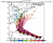
What has been interesting is that as time past, Irma's track has moved farther and farther south and now matches what NOAA is forecasting. Yesterday, the GFS model had Irma hitting SC/NC and today it is moving south of FLA just like NOAA. Yesterday NOAA had the storm lining up on Miami.
This morning the GFS model has the storm making a sharp turn and heading straight up FLA 6-7 days from now. But that is so far out in time that the forecast is really a roll of the dice.
The scary thing is that if Irma goes through the straights of FLA and continues west, that puts in right smack dab in TX. :shocked: :shocked:
But does look like the islands are going to get smacked.
Later,
Dan
What has been interesting is that as time past, Irma's track has moved farther and farther south and now matches what NOAA is forecasting. Yesterday, the GFS model had Irma hitting SC/NC and today it is moving south of FLA just like NOAA. Yesterday NOAA had the storm lining up on Miami.
This morning the GFS model has the storm making a sharp turn and heading straight up FLA 6-7 days from now. But that is so far out in time that the forecast is really a roll of the dice.
The scary thing is that if Irma goes through the straights of FLA and continues west, that puts in right smack dab in TX. :shocked:
But does look like the islands are going to get smacked.
Later,
Dan
