Working rail roads and their tracks.

   / Working rail roads and their tracks. #301  
Yes, about 1000 feet.
Beautiful little place of history and a nice railroad walking trail.
Would be so nice if the trains ran there again.
So much passenger potential. Can’t believe it’s not active.

Looks like a nice walk for a highly populated area.
 
   / Working rail roads and their tracks. #302  
The abandoned sections of rail you were wondering about are maybe 500' west of the "Newlin Grist Mill" in Glen Mills, PA. Next to the abandoned rail line

After seeing MossRoad's google street view I did some poking around. In some areas it's hard to tell what they did as it went west. One road they took out the overpass.
Eventually it met a north south line. They turned it into a wye just SW of Chadds Ford. There is an old bridge with rails in this picture. Just to the left is where the tracks are pulled right before the wye. This was off Bing as it was a better shot to me.
TBN RR Bridge.jpg
 
   / Working rail roads and their tracks. #303  
Looks like a nice walk for a highly populated area.
There still a lot of farming and open space, but yes there are some densely populated areas right alongside those tracks. There’s also light commercial and lots of new retail.
 
   / Working rail roads and their tracks. #304  
Is google earth pro free?

Yes it is for desktops. I run old Garmin Topo maps and can toggle them into Earth. I also run ExpertGPS which can download old paper versions of topo maps. That too can toggle into Earth.
I got ExpertGPS a long time ago and the creator has always provided free upgrades even if you buy a new computer.
 
   / Working rail roads and their tracks. #305  
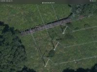
Where the overpass was removed is right next to a 30 acre field I get hay off of. It’s a very small overpass-it would be easy to replace. There was what they used to call a “diamond” there at Chadds Ford Junction. I farm some of the green space under the power lines. I also live in same town.
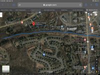
If you look abou 1 mile East up the tracks, you’ll see a huge condo complex. It was built, much to our shagrin, in 1974, just after the line was destroyed by flood. The builders of the complex envisioned a passenger train platform. In fact, we saw the early preliminary drawings. Moving further East, a huge retail center was built with some very attractive stores. If you continue East another 3 miles, it would connect to the new Wawa train station which is under construction and to be completed early 2021 (177 million dollar SEPTA rail station, new track & catenary).
 
   / Working rail roads and their tracks. #306  
After seeing MossRoad's google street view I did some poking around. In some areas it's hard to tell what they did as it went west. One road they took out the overpass.
Eventually it met a north south line. They turned it into a wye just SW of Chadds Ford. There is an old bridge with rails in this picture. Just to the left is where the tracks are pulled right before the wye. This was off Bing as it was a better shot to me.
View attachment 650822

If you look at that bridge, the tracks have been pulled on both ends.
 
   / Working rail roads and their tracks. #307  
They are still there on both ends. They disappear right where the diamond would have been. They go right for quite a ways too. Use regular Google maps sat view. Maybe Hay Dude can get us a local picture. :D
 
   / Working rail roads and their tracks. #308  
If you look at that bridge, the tracks have been pulled on both ends.

Nope, they are still there on the stone trestles coming off the bridge. On the other side theyre buried in dirt. All still there. They ARE removed at the junction (left side of picture).
I just walked on them Saturday.
In fact, 99% of the rails are still there.
Part of the Diamond was ripped up 30 years ago after there was little hope of restoring the line.
I often why they did this. East Penn Railway is always looking for sidings to store cars on. This could have been an easily accessible siding about 1/2 mile long.
 

Attachments

  • 8D11FA41-38BB-40B7-838D-1E2F6A11D7A1.png
    8D11FA41-38BB-40B7-838D-1E2F6A11D7A1.png
    3.6 MB · Views: 120
   / Working rail roads and their tracks. #309  
Here is a satellite pic about 1 mile East of the trestles. Notice the number of housing units clustered on either side of the tracks I lined in blue? This is where our town center is and a rich source of commuters into Philadelphia. Tracks are still there.
 

Attachments

  • 4821441E-AF49-42B2-9623-F54BAA8E63C2.jpeg
    4821441E-AF49-42B2-9623-F54BAA8E63C2.jpeg
    686.6 KB · Views: 107
  • 1E1F4CF8-7715-4A12-BCC8-238B77852E9C.png
    1E1F4CF8-7715-4A12-BCC8-238B77852E9C.png
    5.1 MB · Views: 131
   / Working rail roads and their tracks. #310  
Here is Ames Brothers Monument in Wyoming. The old rails went right by it. Ames Wiki There was an old roundhouse just NE of the spot you can sort of make it out in this sat image.
IMG_1682.JPG
Ames Monument Roundhouse.jpg

It's right off I80. When I was there I wasn't aware of the roundhouse and was really more out exploring for the current RR tunnel that was shifted south a few miles. I couldn't get close to it due to private property.
 

Tractor & Equipment Auctions

2014 D&P WELDING 16FT PRESSURE WASH TRAILER (A52472)
2014 D&P WELDING...
2009 Ford Escape Hybrid SUV (A50324)
2009 Ford Escape...
FORD 555B BACKHOE (A51246)
FORD 555B BACKHOE...
2016 Nissan Murano SL AWD SUV (A50324)
2016 Nissan Murano...
Approximately 250 Traffic Cones (A51573)
Approximately 250...
New Lewis Brothers MFG DB2 Poultry Housekeeper (A52748)
New Lewis Brothers...
 
Top