Here we go again -- Katrina

/ Here we go again -- Katrina #1  

OkeeDon

Veteran Member
Joined
Jul 4, 2003
Messages
1,790
The attachment speaks for itself.

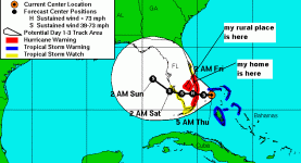
So far, the eye is supposed to stay about 40-50 miles south of us, but there are different troughs that are pushing the storm up and down -- one track predicts it coming in north of Lake Okeechobee, which would go directly over both our home and the Okeechobee property.

This storm is predicted to be more of a rain event than a super serious wind event; they're predicting 6 to 12 inches over the entire area, with some areas getting up to 15 to 20 inches. The areas to the north of the storm generally get more rain.

Looks like I'll be flooded again, before I got all the drainage done. That will wash away some of it and delay the rest of it for weeks or months while it dries again. The area is saturated. The folks on the coast are suing the water management district for releasing fresh water from the lake, which is killing the estuaries on the coast. But, if they don't, the lake will break the levees and flood most of South Florida.

We do NOT need this storm...
 

Attachments

  • 721281-katrina1.gif
    721281-katrina1.gif
    15.4 KB · Views: 325
/ Here we go again -- Katrina #2  
Yup, I just got finished burning up the residue from last year's hurricanes (see attached pic).

This one could be a major flood disaster though, but there are still another dozen or so storms forecasted for the rest of the season, that works out to at least one per week, so get ready!
 

Attachments

  • 721287-Grapple Fire2.jpg
    721287-Grapple Fire2.jpg
    92.9 KB · Views: 222
/ Here we go again -- Katrina #3  
Don

You are having it bad, sorry. Having moved inland out of the Galveston Bay area I wouldn't mind if we got a hurricane but they don't seem to be able to come this far west anymore.

Vernon
 
/ Here we go again -- Katrina #4  
My oldest daughter lives down there, I had some sleepless nites last year. I'll keep all your Floridians in my prayers.
 
/ Here we go again -- Katrina #5  
Don, isn't the lake currently above flood level now?

Sounds like a major disaster is in the making with this slow moving storm.....nowhere for the H2O to go. /forums/images/graemlins/frown.gif
 
/ Here we go again -- Katrina
  • Thread Starter
#6  
No, the S Florida Water Management District has been releasing water out of the lake into the Caloosahatchie River (towards the Gulf) and the St. Lucie Canal (towards the Ocean). But, if they stop dumping the water, the Lake would rapidly get back to over-full.

If a storm surge pushes the Lake water against the levees, it could break through them and cause massive flooding. Hurricane-driven flooding in 1925 and 1928 killed more than 3,000 people, and that's before the populations built up to current levels! The Herbert Hoover Dike was constructed all the way around the Lake to prevent it from happening again, but the dike is threatened when the Lake is too full in storm season.

The fresh water being dumped from the lake is diluting the brackish water in the St. Lucie estuary, causing fish kills, lesions on fish, algae blooms and other not so nice stuff. It's gotten so bad on the coast that the Martin County Commission has voted to sue the water management district. There are protests, lots of angry words, etc.

However, the head of the district Army Corps of Engineers, who works with the water management district to control flooding, came to Martin County (Stuart, Palm City) last week and taped an interview. In it, he asked plaintively, "Where should I put the water? It rains; it has to go somewhere." People said, "Not in our estuary." Bluntly, he replied, "Then, can you give me your address? I can divert it to your living room." Still, they don't get it -- they think a judge can somehow stop the water.

The whole thing is a complex mess which involves water from as far away as Orlando coming down the Kissimmee River basin into the Lake, with Big Sugar using most of the land South of the Lake, with endangered species affected if they let the water flow to other areas South of the Lake, and the coastal estuaries affected if they release the water.

The best the Corps and the water management district can do right now is pursue a policy of "shared adversity" I've mentioned before; this is part of what's causing my land North of the Lake to flood more in the past 3 years than it has in the previous 20 years or more.

There are some historical reasons why it got this way; essentially, back in the early part of the 20th Century there were very effective maeasures to reduce flooding but with no thought given to the ecological balance. Primarily, the Kissimmee River was channelized and all of central Florida now drains quickly into the Lake. They're fixing it, actually restoring the oxbows and flood plains along the Kissimmee, and they have a $1.2 Billion package currently in Congress to create additional reservoirs and holding areas on more than 250,000 acres of land, but those solutions are years away.

I have a foot in both camps, because my land in Okeechobee is affected and my home in Port St. Lucie is only a couple of hundred yards from the North Fork of the St. Lucie River, which is part of the estuary that is affected. I can see both sides, but I have to favor the WMD and the Corps, because flooding will kill people, and dumping the fresh water kills fish. I favor people over fish.
 
/ Here we go again -- Katrina #7  
SkyPub,

I don't think the problem is going to be around the lake or even in the water managment areas south of the lake. The levees around Lake O are 20-30 feet tall. They are huge. Even if the lake filled up, all of the water management areas south of the lake can hold a tremendous amount of water. The levees are not as big/tall but they area they contain is huge.

If the WMD starts pumping water back in the water management areas it kills off the wildlife. There are quite a few animals out there that depend on the islands and them islands ain't much to talk about height wise.

I use to live where the storm seems to be coming ashore. There is some real low land down there. Any large rainfall is going to cause flooding. They built on land that was full of cypress tress for goodness sake. There just is no way for the WMD to pump that water out of there fast enough even if they tried to fill up the managment areas or dump it out to sea.

I left 13 years ago and they where building on swamp land. That is all that really is left. Course it was all swamp land until it was drained but even with the canals it still was swamp land. There is a little town on the Broward/Palm Beach county line that is in a major flood zone. Lots of expensive house where built out there and the stom looks like its hitting at the county line.

If they get the rain that is forcast its going to be ugly.

Later,
Dan
 
/ Here we go again -- Katrina #8  
Don,
I know exactly what you are going through. My wife and I decided to leave the "Sunshine State" after being there for the last 25 years. The increase in hurricane activity the last few years certainly was a factor in our decision. I hope everything works out for you and yours.

Be safe,

John
 
/ Here we go again -- Katrina
  • Thread Starter
#9  
Well, we're gettijng a complete miss this time. The storm is coming ashore about 85 miles south of us, with bands out about 80 miles. It's been pretty dry in Port St. Lucie according to my wife; they lifted the hurricane warning for the Treasure Coast (the area north of Plam Beach County where we live).

I'm out in Okeechobee at the moment, about 8 miles north of the north end of the Lake, sitting in the motor home. There have been a couple of bands of rain come through, but not enough to cause puddles - reported to be about 1/4". We lucked out. I hope those further south are doing OK; according to the TV reports, it's not too bad down there.
 
/ Here we go again -- Katrina
  • Thread Starter
#10  
I don't know if anyone is interested in the peculiarities of Lake Okeechobee and the various problems associated with it, but I just heard on TV what to me was an interesting tidbit.

Buckhead Ridge is a community on the North shore of the Lake, about 10 mile SW of the city of Okeechobee (and about 8 miles due South of my property). Clewiston is down near the Southwest corner of the lake. They just showed on TV that the lake level at Buckhead is 15.17', while the level at Clewiston is 16.19'. What this means is that the storm's counter-clockwise rotation is creating a surge that is pushing the water from North to South. By the time the storm passes (it's currently about 60 miles south of the lake), the surge is expected to reach 3'. The level will be over 18' in the southern end of the lake. It's this surge that threatens the dike that surrounds the lake. The TV announcement was that experts expect the dike to withstand this surge, but they are watching it closely. The dike is probably some 30' high at that point, but the battering from the surge is what can weaken it.
 
/ Here we go again -- Katrina #11  
I find it amazing the degree of uncertainty that exists with these things. That quick southerly jog after it hit shore was similar to Charley last year. It chugged it's way up the west coast and all of a sudden, out of the blue, it hangs a rudy into charlotte harbor and gets sucked up the Peace River. In 35 years I never boarded up till last year. I would have swore that Charley was headed right for my house... /forums/images/graemlins/shocked.gif

Whats amazing is no matter how hard they try to predict...it's gonna go where it wants to go when it wants to go there. I don't think people, as a general rule, fully understand that you can't wait till the last minute to see what's gonna happen because you don't want to put all that STUFF away and have to take it back out.... /forums/images/graemlins/grin.gif

Glad to hear you dodged a bullet. Over here in the South Tampa area there talkin bout some rain and wind mostly.
 
/ Here we go again -- Katrina #12  
Don,

The slushing of Lake O's water from the north to the south is why the Hoover dike was built. There was a hurricane in the 20's or 30's that killed thousands of people around Lake O. The real number of deaths will never be known.

I'm surprised at the number of deaths so far from Katrina. The ones I don't understand is the missing family of 5 that went on a boat trip Thursday to/on the west coast. The report was not very clear on where the boat was from or where it was traveling. Two parents, two teenagers and a four year old. I sure hope the report has a better answer.

Later,
Dan
 
/ Here we go again -- Katrina #13  
I have photos of my grandparents taking my mother and her brother and sister out of the second story window of their home into a rescue boat in 1928 when that storm flooded the Big O and killed so many people. The tops of the Royal Palm trees were just barely sticking out of the water in the background.

Their two story Spanish stlye home was built in 1915 in Fort Lauderdale on the edge of Port Everglades in Broward County. Our family owned all the land that is now Port Everglades.

Also have pics of three 600-foot long steel freighter ships high and dry in downtown Ft. Lauderdale 2 miles INLAND of Port Everglades! /forums/images/graemlins/blush.gif

That was the storm that resulted in the Dam around the Big O, my grandmother told me most of the people died of food poisoning and water contamination in the aftermath of the storm.
 
/ Here we go again -- Katrina #14  
Well it now looks like once again a Hurricane is headed to the Panhandle......at least I'm inland, and not on the water.

Hopefully it won't be to bad around here.
 
/ Here we go again -- Katrina #15  
The National Weather Service is predicting Katrina to make Class IV prior to landfall, that simply means get out now while there is still time.
 
/ Here we go again -- Katrina #16  
Personally am not going to get worried until it starts to turn north. About 72 hrs until landfall according to the 4pm CDT NHC prediction. The problem is the northeasterly winds keeping it from turning north. The last issuance the NHC left open the possibility for more "adjustments" to the track (with the center of the cone of probability aiming for southern Mobile county). <sigh>

Steve
 
/ Here we go again -- Katrina #17  
From weather.com:

There was a report of a family of five missing that was on a boat off southern Florida during the hurricane, but the good news they were all rescued by the U.S. Coast Guard.
 
/ Here we go again -- Katrina #18  
Barton,

I saw the report that they had been found. They where very lucky. They played a bit of Gilligans Island.

The reports I saw was that they where in a 24 foot boat. I would like to know why they went out in the first place. My guess is that they thought the storm would track well to the north and they where ok to go. /forums/images/graemlins/blush.gif And then it turned south.....

I just hope New Orleans can escape this mess somehow. This sure looks to be The One. A guess another few hours and we will know. With 10 inches of rain so far the flooding is going to be bad....

Later,
Dan
 

Marketplace Items

2009 Ford F-550 4x4 Ext. Cab Brush Fire Truck (A59230)
2009 Ford F-550...
2025 Safety Basket Forklift Attachment (A59228)
2025 Safety Basket...
2003 McCormick XTX 185 XtraSpeed Tractor (A61307)
2003 McCormick XTX...
WHIRLPOOL REFRIGERATOR/FREEZER W/ICEMAKER (A60432)
WHIRLPOOL...
BOMAG BW213 SMOOTH DRUM ROLLER (A58214)
BOMAG BW213 SMOOTH...
PT 1000 Gallon Supply Tank (A57149)
PT 1000 Gallon...
 
Top