HIGH RISK of Severe Weather

   / HIGH RISK of Severe Weather #21  
Here's some footage of a neighborhood down the street from my wife's work. Tornados path came to within a 1/2 block from the nursing home my wife works at.
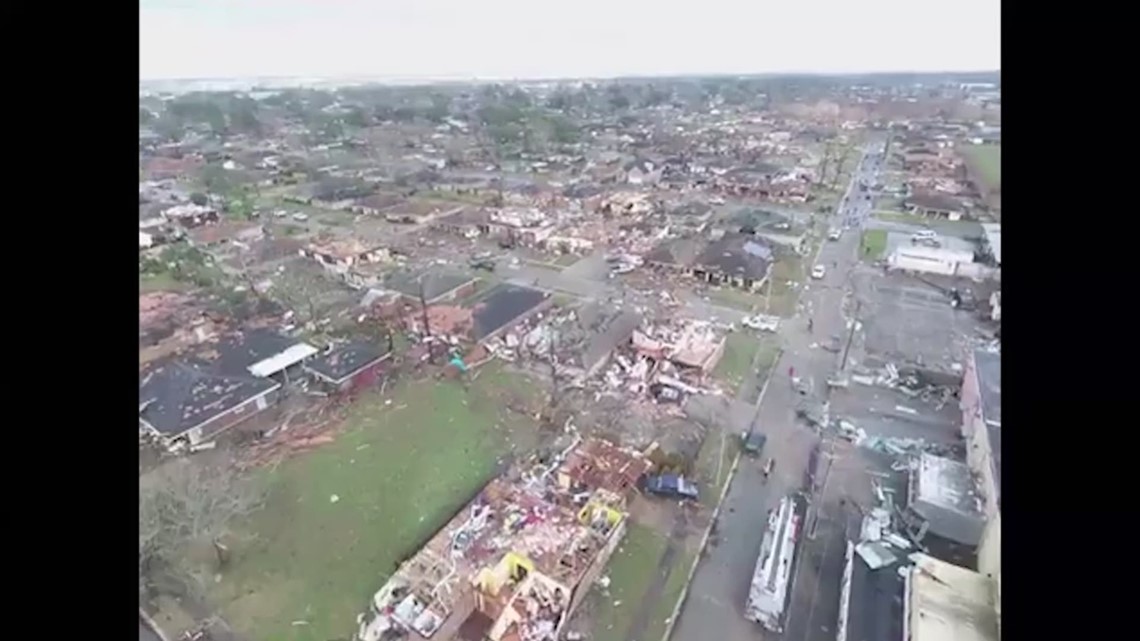

Here's some drone footage of west Little Rock.

 
   / HIGH RISK of Severe Weather #22  
Large cell passed just south of us, looks like it used up some energy and the line behind it weakened a bit
 
   / HIGH RISK of Severe Weather #23  
The line passed and we are ok. It weakened a lot before it arrived, but it was still intense
 
   / HIGH RISK of Severe Weather #24  
A lot if the schools in our area, west central Illinois, didn’t have school yesterday for safeties sake. Everything missed us but there were tornadoes and hail in Illinois.
 
   / HIGH RISK of Severe Weather #25  
We got some damage way south of here. Went to the basement. Serious wall cloud, with rotation, hail, rain, wind. No damage here. 70's yesterday, 28 this morning, with a skiff of snow.
 
   / HIGH RISK of Severe Weather #26  
We got some damage way south of here. Went to the basement. Serious wall cloud, with rotation, hail, rain, wind. No damage here. 70's yesterday, 28 this morning, with a skiff of snow.
We've had extreme temp swings and high winds for over a year now. We are also on the verge of drought. Haven't had any eroding rain runoff for a year. They'll predict 2" and we'll get .2".
 
   / HIGH RISK of Severe Weather #27  
All local TV programming went to weather last night around 10:00pm. Big line of thunderstorms being chased by a bow echo coming across north west Indiana. So we watched it on the radars. They kept tracking it as going to hit us directly. The bow echo was catching up to the thunderstorm line. It was producing 78mph winds ahead of it. There were radar indicated tornadic rotations in the thunderstorms. We were getting a bit concerned and I was thinking of heading to the basement.

Then the weather guy said watch this. When that bow echo catches up to the thunderstorms, it will undercut the updrafts and kill everything. It's just a matter of when.

So about 2 minute before it was predicted to hit us, the bow echo caught the thunderstorms, the wind here just dropped to nothing. And it was over. Just rain after that.

Just broke apart in an instant. Pretty interesting.
 
   / HIGH RISK of Severe Weather #28  
All local TV programming went to weather last night around 10:00pm. Big line of thunderstorms being chased by a bow echo coming across north west Indiana. So we watched it on the radars. They kept tracking it as going to hit us directly. The bow echo was catching up to the thunderstorm line. It was producing 78mph winds ahead of it. There were radar indicated tornadic rotations in the thunderstorms. We were getting a bit concerned and I was thinking of heading to the basement.

Then the weather guy said watch this. When that bow echo catches up to the thunderstorms, it will undercut the updrafts and kill everything. It's just a matter of when.

So about 2 minute before it was predicted to hit us, the bow echo caught the thunderstorms, the wind here just dropped to nothing. And it was over. Just rain after that.

Just broke apart in an instant. Pretty interesting.
I was watching the same thing. Prayers answered
 
   / HIGH RISK of Severe Weather #29  
One of our weather forecasters said there is a chance we may get to do it all over again next Tuesday.

I hope he is wrong.
 
   / HIGH RISK of Severe Weather #30  
We got pounded from this. 8-10" of super heavy snow into the night. Power flickered around 1AM and it seemed like we lost a leg as some lights were behaving weirdly for a bit. Flicked on and off a few times for 15 min and then stayed on but later around 3AM it went totally dead until like 7AM when it came back on. I was hearing limbs/trees falling in the woods into the night but it looks like nothing close enough to damage any buildings. Of course, I cut things back quite a bit to minimize those chances when I built but there are still trees that can hit something if they fall badly.

Local news says this puts us at #3 for most snowfall in a season...so far. Another decent storm or two and #2 is in reach but #1 would require like another foot from where we are now and that seems unlikely but you never know...

Take a look at that poor little birch in the turnaround. I hope it will spring back!
PXL_20230401_174200180.jpg
 

Tractor & Equipment Auctions

2012 UNVERFERTH 6-INCH FRONT WHEEL SPACER KIT FOR 10 BOLT HUB (A52748)
2012 UNVERFERTH...
2009 IC Corporation PB105 School Bus (A51692)
2009 IC...
WIGGINS 5K FORKLIFT (A52472)
WIGGINS 5K...
2010 Ford Edge SE SUV (A51694)
2010 Ford Edge SE...
(1) 14ft Tarter Gate (A51573)
(1) 14ft Tarter...
2012 MACK CXU PINNACLE (INOPERABLE) (A52472)
2012 MACK CXU...
 
Top