buckeyefarmer
Epic Contributor
Pictures would help.
Does the creek show up as a blue line on a USGS map? If so, then it is navigable waters of the US and is a whole nother Ballgame.
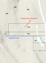
No, the creek that traverses my property doesn't show on a USGS map. But the creek that it eventually feeds into, about 1,000 feet later, does. That creek is a well known trout stream.
As I may have mentioned prior, I learned that the area that Fred wants to drain is a federally regulated freshwater (non-tidal) wetland (shows up on the National Wetlands Inventory) hence considered a US body of water. Certain activities would require a permit from US Army Corps of Engineers. However it doesn't appear to be regulated by New York State Dept. of Environmental Conservation per their digital mapping system. To be protected under the NYS Freshwater Wetlands Act, a wetland must be 12.4 acres (5 hectares) or larger.
I will try to get some pictures up.
I caught Bob yesterday as he was raking leaves and asked him if Fred ever spoke to him about a plan to drain standing water from his (Fred's) land across Bob's land and into the creek that traverses my property. Bob said Fred approached him months ago and ran the idea by him. At that time Bob never committed either way to allowing excavation on his property. In a nutshell, I told Bob that the heavy equipment operator may someday ask for permission to work on his land and that I wouldn't be happy about any plan to divert water into a creek that already overflows its banks (onto my primary horse pasture and 50 feet from my septic drain field) during heavy rainfall. I also alerted Bob to the fact that the area in question, both his property and Fred's, is deemed wetland by US Fish & Wildlife and can be readily identified on the Wetlands Inventory map. Bob was surprised to learn of the wetland designation. He got the message. I will also talk to Fred when I see him.
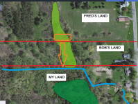
The attached map is taken directly from US Fish & Wildlife Wetland Inventory. The wetland areas are shaded green. The creek, which I drew, is blue and the area that Fred hopes to drain is encircled in orange (stripes).
Bob's wife had the best solution. She said Fred needs a pair taller rain boots.
sourcePruitt, as Oklahoma attorney general, had sued EPA over the regulation, saying it ç*¥surps state authority, ç*¥nlawfully broadens the definition of waters of the United States and imposes 渡umerous and costly obligations on landowners.
I caught Bob yesterday as he was raking leaves and asked him if Fred ever spoke to him about a plan to drain standing water from his (Fred's) land across Bob's land and into the creek that traverses my property. Bob said Fred approached him months ago and ran the idea by him. At that time Bob never committed either way to allowing excavation on his property. In a nutshell, I told Bob that the heavy equipment operator may someday ask for permission to work on his land and that I wouldn't be happy about any plan to divert water into a creek that already overflows its banks (onto my primary horse pasture and 50 feet from my septic drain field) during heavy rainfall. I also alerted Bob to the fact that the area in question, both his property and Fred's, is deemed wetland by US Fish & Wildlife and can be readily identified on the Wetlands Inventory map. Bob was surprised to learn of the wetland designation. He got the message. I will also talk to Fred when I see him.
The attached map is taken directly from US Fish & Wildlife Wetland Inventory. The wetland areas are shaded green. The creek, which I drew, is blue and the area that Fred hopes to drain is encircled in orange (stripes).
Bob's wife had the best solution. She said Fred needs a pair taller rain boots.
CuteI think this administration is leaning to "drain the swamp".
")