I'm contemplating investing in timber land in New England

   / I'm contemplating investing in timber land in New England #71  
GIS software is thousands i think? Its very expensive. Arc view basically has a monopoly and is extremly pricy for a small business let alone a landowner just wanting to map his place.

GIS can be FREE, google GRASS GIS - GRASS GIS - Home,
look at QGIS http://www.qgis.org/http://www.qgis.org/.

ARC GIS is EXPENSIVE. I used to teach it to the Army. People that use it can charge for it.

But using a GIS is not like using a wordprocessor. There's probably a minimum 2 month learning curve to create a finished product. And since most Freddy Farmowners only own 1 farm it's not worth the effort to learn a complicated piece of software to draw something that will hardly change.

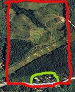
Most of what one would need for "mapping" their land can be done from freely available digital photos in Microsoft Paint.
1Untitled.jpg

If you get the "imagery" as it is called, drawing lines to show where the pines are is easy. You should KNOW your land. It's not like when I was in Serbia trying to draw lines for the Dayton Agreement to separate the Serbs and the Croats. You shouldn't have to worry about incoming or mines. You can walk out there and check the fence line and the swamp.

Of course to some of you welding is easy, and I've yet to get beyond SuperGlue :)
 
   / I'm contemplating investing in timber land in New England #72  
Wow, dave1949, you are a busy guy. We decided to retire to somewhere warmer after the Great Ice Storm of 1998 or whenever it was. We are really self-sufficient in whatever we might have needed, so we were OK, but it's nice to be warmer for a while. Yeah, I could write a book.
Burl Ives---how did you know? I don't recall that tune but packed away in some box I have some of his 1960's albums. Any, yeah, bingo and beano, the offical state games.

You know, we dithered on that warmer choice thing. About this time of year, we envy people who are snow free. But, all in all, we are satisfied. There aren't many places you can buy a good-sized chunk of land at rural Maine prices, that was a big attraction. I'm pretty sure our stone hasn't stopped rolling yet. :laughing:
 
   / I'm contemplating investing in timber land in New England #73  
there you go on the google grass gis thing, but I agree the normal landowner can print out google maps and then mark it up and label it with a simple key.

Im a professional forester and learned enough to maneuver in gis and input points and polygons and things as well as edit and label on the maps etc you make. NOw a days I have others that make and maintain the maps for me. The way you have to get the layers up and all the stuff needed to navigate it easily and the fact that it changes a bit each update I am way out of practice on it. I cant really do anything anymore on it, which I think is a shame but my job does not require me to use it for anything and I don't even have it on my computer anymore. When I need maps I just get someone to make the ones that I need. I mostly handle timber sales, the way our agency works is that the complete package is handed to me and I basically market the timber and collect the money and oversee the contract. Others make the prescription mark it and make the maps that I use.
 
   / I'm contemplating investing in timber land in New England #74  
GIS can be FREE, google GRASS GIS - GRASS GIS - Home,
look at QGIS http://www.qgis.org/http://www.qgis.org/.

ARC GIS is EXPENSIVE. I used to teach it to the Army. People that use it can charge for it.

But using a GIS is not like using a wordprocessor. There's probably a minimum 2 month learning curve to create a finished product. And since most Freddy Farmowners only own 1 farm it's not worth the effort to learn a complicated piece of software to draw something that will hardly change.

Most of what one would need for "mapping" their land can be done from freely available digital photos in Microsoft Paint.

View attachment 309988

If you get the "imagery" as it is called, drawing lines to show where the pines are is easy. You should KNOW your land. It's not like when I was in Serbia trying to draw lines for the Dayton Agreement to separate the Serbs and the Croats. You shouldn't have to worry about incoming or mines. You can walk out there and check the fence line and the swamp.

Of course to some of you welding is easy, and I've yet to get beyond SuperGlue :)

Thanks for steering in the right direction. It looks like MS Paint would do some of what I want. I will try that out.

I see there is a GRASS-Garmin interface: GRASS GIS manual: v.in.garmin. I can see how that is going to get complicated quickly.
 
   / I'm contemplating investing in timber land in New England #75  
Yea even on free GIS stuff, knowing how to use it(meaning GIS software) it will still be complicated, when you try and import raw data in the form of lines, polygons and points onto that map. The file nameing, correcting if need be etc is the really complicated part for me.

Give me a gis database with the layers open and i can turn them on and off shade them label them make maps, measure areas, draw lines etc, maybe even open another layer if its not hidden in to many branch files that i dont know where to look. But when you go to add data when hooking up a gps thats where the guys earn thier money.
 
   / I'm contemplating investing in timber land in New England #76  
Another GIS alternative is to use google earth. It allows you to measure angles and distances, which can be useful for plotting points. If you have something like a stone wall or easily recognizable feature you can get relatively close. You can also hook it up with a simple GPS and then plot your tracks, which isn't 100% accurate, but gets you within 10- 20 feet or so, which is close enough in many cases. That's how I plotted my land when inventorying what I had.
 

Tractor & Equipment Auctions

John Deere 6120E (A50323)
John Deere 6120E...
2015 Revere Shasta 27DB 5th Wheel Travel Trailer (A51694)
2015 Revere Shasta...
2012 International ProStar Sleeper Cab Truck Tractor (A51692)
2012 International...
2003 Ford Excursion 4x4 (MPV), VIN # 1FMSU43PX3EC07978 (A51572)
2003 Ford...
Toro Zero Turn (A50324)
Toro Zero Turn...
2010 Chevrolet Equinox SUV (A51694)
2010 Chevrolet...
 
Top