newbury
Super Star Member
- Joined
- Jan 8, 2009
- Messages
- 14,147
- Location
- From Vt, in Va, retiring to MS
- Tractor
- Kubota's - B7610, M4700
GIS software is thousands i think? Its very expensive. Arc view basically has a monopoly and is extremly pricy for a small business let alone a landowner just wanting to map his place.
GIS can be FREE, google GRASS GIS - GRASS GIS - Home,
look at QGIS http://www.qgis.org/http://www.qgis.org/.
ARC GIS is EXPENSIVE. I used to teach it to the Army. People that use it can charge for it.
But using a GIS is not like using a wordprocessor. There's probably a minimum 2 month learning curve to create a finished product. And since most Freddy Farmowners only own 1 farm it's not worth the effort to learn a complicated piece of software to draw something that will hardly change.
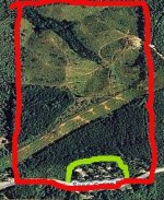
Most of what one would need for "mapping" their land can be done from freely available digital photos in Microsoft Paint.

If you get the "imagery" as it is called, drawing lines to show where the pines are is easy. You should KNOW your land. It's not like when I was in Serbia trying to draw lines for the Dayton Agreement to separate the Serbs and the Croats. You shouldn't have to worry about incoming or mines. You can walk out there and check the fence line and the swamp.
Of course to some of you welding is easy, and I've yet to get beyond SuperGlue
