Best Way to Measure Elevation Profile of Land?

   / Best Way to Measure Elevation Profile of Land? #11  
Does the county have a GIS (geographical information system) website?
I have a piece of land in Georgia and the county has a GIS site in the land tax website which shows the elevation in 10 foot intervals. Once I was able to get it to show me 2' intervals, but not since. Maybe someone in the tax office for the county can get it to print with elevations in 2' or so elevations.
 
   / Best Way to Measure Elevation Profile of Land? #12  
I would not trust an iphone gps for grading. As far as I know (unless it has changed) any consumer grade gps is only considered accurate to 3 meters for coordinates. I doubt altitude is any better.

As mentioned, it would be better to borrow/rent a laser.
 
   / Best Way to Measure Elevation Profile of Land?
  • Thread Starter
#13  
I will check into the county info.

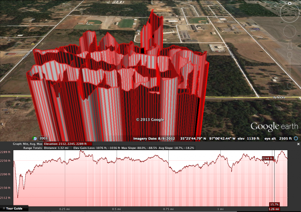
I have ruled out the iphone GPS. I walked the land in a grid pattern recording with an iphone GPS app. I then opened it in Google Earth and measured differences in intersecting points to check pass-to-pass accuracy. Many were over 10' off from each other. I would like to have +/- 6" height accuracy in a 20'x20' grid.

I am not going to be grading by these measurements. I only want to make a 3D model for me to mess around with.

Thanks for all of the comments and suggestions everyone!
 
   / Best Way to Measure Elevation Profile of Land?
  • Thread Starter
#14  
Here is a screenshot from Google Earth. For some reason all waypoints were 1100' over actual elevation... so the track appeared to be a skyscraper lol. Hopefully you can see what I mean by the pass-to-pass inaccuracy.

ScreenShot2013-09-29at71714PM_zps731db725.png
 
   / Best Way to Measure Elevation Profile of Land? #15  
If it's 2 acres and 450 feet one way that means it's about 200 feet the other, assuming it's rectangular. With a measurement every 20 feet that's 23x10 measurements, or 230 total. If you spend 10 minutes on each measurement that's 38+ hours, or about a week. So the challenge is doing it in a reasonably efficient manner so it doesn't take you forever. There are really two parts to this. One is laying out a 20x20 grid with reasonable accuracy. The other is taking height measurements with reasonable accuracy.

Here's how I would do it, assuming the ground is reasonably clear, flat and free of obstructions. You can get a laser that will shoot the 200 foot direction. I would mark two corners along the 450' dimension. I would walk that line with a measuring wheel , and use a spray paint marking wand to put a dab of paint every 20 feet. Then I would do the same thing along the other 450' edge.

(One thing you'll have to ask yourself is how important it is to make a true rectangle at this point. If you don't want to just eyeball it, and you don't have any landmarks, once you've got your first two corners down you'll want to use a 3-4-5 triangle to find a right angle to them, and then use the measuring wheel and the laser to measure out two perpendicular sides of the same length, and then the laser to connect them.)

You'll need two laser target cards and two stakes, probably six feet or so. Use a ruler and a sharpie to turn one stake into a measuring stick. Put the target card on the other and pound it into one of your paint blobs. Put the laser on the matching blob on the other side of the lot and see if you can hit the target. Now walk from the laser to the target carrying the measuring stake, the other target, a notebook and pen, and measuring with the measuring wheel. (You'll need four hands!) Every 20 feet stop, get the target into the laser beam, and use the measuring stick to measure the height above ground. Record in the notebook. When you reach the other end move the stake to the next blob, move the laser to the next blob and repeat until finished.

A helper would be real handy, because otherwise you have to make a round trip for each pass to move both ends. With a helper you can do each pass in a single trip so you save half the walking. Even so it's about a mile of walking.
 
   / Best Way to Measure Elevation Profile of Land? #16  
I would find a buddy or a rental center with a laser or at least a basic level the kind that takes two people and do your grid.

Might even check at Sears use to be able to buy one for around a couple hundred bucks. This would be my preference especially if you plan on doing the dirt work for your house other buildings yourself.

Just my 2 cents.
 
   / Best Way to Measure Elevation Profile of Land? #17  
a fairly inexpensive builders level and a rod.
 
   / Best Way to Measure Elevation Profile of Land?
  • Thread Starter
#19  
Thanks farmer! You are correct on the approximate measurements, and it is mostly open. My next task is locating a laser...

I don't mind putting the time and effort into this. Once it is done I will have the info for the rest of my life.

Thanks everyone!
 
   / Best Way to Measure Elevation Profile of Land? #20  

Tractor & Equipment Auctions

Tote Tank (A50860)
Tote Tank (A50860)
1997 EZ-GO TXT Electric Golf Cart (A50860)
1997 EZ-GO TXT...
2 Vintage Metal Signs (A48082)
2 Vintage Metal...
CASE CX37C EXCAVATOR (A51242)
CASE CX37C...
2002 Ford F-150 4x4 Ext. Cab Pickup Truck (A50323)
2002 Ford F-150...
2017 Ford F-550 Valve Maintenance Truck (A50323)
2017 Ford F-550...
 
Top