Using GPS to lay out a field

   / Using GPS to lay out a field
  • Thread Starter
#21  
I clicked on the link to look at a pic of the equipment. It looks like it is just the guts of a GPS receiver. I saw where you mentioned putting a metal tray under them for reflections, which is called multi path. Surveying equipment has that stuff built into the housings and the software also helps in rejecting multi path.

Does your equipment just track American satellites? I am not sure how many are floating around up there now. Gps(USA), European (galelio), Japanese, Chinese (Bediou sp?) and Russian (Glonass). I first started using GPS about 1993 and at that time there were long periods of the day you could not work because there were not enough satellites. With RTK you need 5 to get a fixed solution and 4 to maintain it, that assumes no obstructions. These days it not uncommon to track 15 to 20 satellites.

Do you have this in some kind of housing? Are you using some kind of pole? Kudos to you to get it working, that is way beyond me.

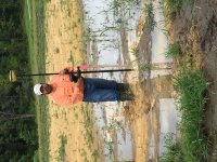
The kit is just a circuit board although it comes with a GPS antenna and a radio antenna. It looks like this:
C94-M8P-4-CI.png


This is the housing I'm using:

903-00.jpg

Small Plastic Project Enclosure - Weatherproof with Clear Top ID: 93 - $9.95 : Adafruit Industries, Unique & fun DIY electronics and kits

I drilled holes in it for the antennas and the USB cable.
 
   / Using GPS to lay out a field #22  
This is very innovative. The limitations of your paint wand are impacting your accuracy much more than the limitations of your GPS. I would look into buying what is called a rover rod. It is a collapsible pole that is 2 meters tall. You mount your receiver on the top of it, it has a bubble level mounted on the side of the pole so that you can tell it is plumb, and it goes down to a point on the bottom. Using one of these I have done some very precise things such as embedding anchor bolts into concrete slabs as they were poured that later the columns for the building were bolted to. Not much room for error there.
 
   / Using GPS to lay out a field
  • Thread Starter
#23  
I tell you that痴 a heck of a setup. I assume the black box in the center is the GPS antenna? One thing that will help is to get that setup in the air. We usually use a 2 meter pole to get it up over our heads and the base sets on a tripod about 5.5 feet high.

Thanks. I think I could mount it on a camera tripod pretty easily. It's good to hear how it's "really" done, I started this not knowing anything about GPS.
 
   / Using GPS to lay out a field #24  
The way we do it is with something called a Tribrach. It mounts to a tripod, one that is a lot heavier than one for a camera. The tribrach contains an optical plummet and a level bubble. The optical plummet is just a fancy plumb bob that uses optics instead. The tribrach lets you screw it to the tripod and be over a point and level. The GPS antenna usually has a set of threads that let you attach it to the tribrach.

This setup lets you setup over a point in an exact manner, which is sometimes a known monument or a new point. For new points they can often just be a random place that is easy to get to, we often use large nails or rebars. The idea is to always use the same point as your base so the coordinates are consistent. The threads on this stuff, the tribrach and GPS pole are just standard plumbers pipe threads I think.

Pretty ambitious to build your own GPS system and it looks like you pulled it off.
 
Last edited:
   / Using GPS to lay out a field #25  
3CE4603E-69B1-47F6-8CD4-8AF66573920F.jpeg

The attached photo is our old GPS system a Topcon being run by one of my coworker. On top of the pole is the GPS antenna, it also contains the radio and the chips and board. Half way down is the data collector. We also have a 35 watt radio that we can setup with the base that gives us a radio range of over 10 miles or we can use the built in radios which have a range of over a mile.

Our new system, a Trimble has all of that plus a VRS system. With this we can use a hotspot to link up to the internet and use multiple bases tied into the system. Some states offer this service for free, in Illinois we have to pay for it, $2500 a years as I recall. With VRS you don’t need a base.

One thing about your system is it must have RTK software built in, called an RTK engine. It’s not just the hardware that makes this all happen but the software is an even bigger part of it.
 
   / Using GPS to lay out a field
  • Thread Starter
#26  
View attachment 652700

The attached photo is our old GPS system a Topcon being run by one of my coworker. On top of the pole is the GPS antenna, it also contains the radio and the chips and board. Half way down is the data collector. We also have a 35 watt radio that we can setup with the base that gives us a radio range of over 10 miles or we can use the built in radios which have a range of over a mile.

Our new system, a Trimble has all of that plus a VRS system. With this we can use a hotspot to link up to the internet and use multiple bases tied into the system. Some states offer this service for free, in Illinois we have to pay for it, $2500 a years as I recall. With VRS you don’t need a base.

One thing about your system is it must have RTK software built in, called an RTK engine. It’s not just the hardware that makes this all happen but the software is an even bigger part of it.

Of all the places he had to pick that exact spot to take a reading?
 
   / Using GPS to lay out a field #27  
That’s home plate on a baseball field. It’s a good example of when the model for machine control isn’t done correctly. We were trying to figure out the problem.
 
   / Using GPS to lay out a field
  • Thread Starter
#28  
One thing about your system is it must have RTK software built in, called an RTK engine. It's not just the hardware that makes this all happen but the software is an even bigger part of it.


The U-Blox chip contains a GPS receiver and RTK software in a single chip. If you look at this picture:
C94-M8P-4-CI.png


The blue square on the left is the radio transceiver to communicate with the other unit. The U-Blox chip is the metallic square on the right. All of the RTK calculations are done inside that chip. It's pretty amazing considering that chip sells on the U-Blox website for about $80.

Our new system, a Trimble has all of that plus a VRS system. With this we can use a hotspot to link up to the internet and use multiple bases tied into the system. Some states offer this service for free, in Illinois we have to pay for it, $2500 a years as I recall. With VRS you don't need a base.

There are free networks that transmit over the Internet but of course there aren't any with base stations near me. It seems like the base station has to be within 6 miles of the rover to get good accuracy. If I were going beyond playing with this I would ditch the radios and have the base and rover communicate over the Internet. The rover is attached to the smartphone and needs Internet access anyway to access the field definition map so the rover can communicate through it. I would set up a base station somewhere with a good view of the sky and Internet access within six miles of me and connect it to a free network. Then I'd have the rover access the free network through the smartphone.

For about $200 you can get a board that just has the U-Blox chip and jacks for USB and an antenna:
SparkFun GPS-RTK Board - NEO-M8P-2 (Qwiic) - GPS-155 - SparkFun Electronics

Once there's an Internet-connected base station nearby that board plus a smartphone becomes the price of admission.

There's also a newer version of the chip that's about $20 more:
SparkFun GPS-RTK-SMA Breakout - ZED-F9P (Qwiic) - GPS-16481 - SparkFun Electronics

I haven't used it but this reviewer says it gives markedly better performance:
Comparing a uBlox F9P with a M8P with RTK - Blog - ArduPilot Discourse
 
   / Using GPS to lay out a field #29  
That’s home plate on a baseball field. It’s a good example of when the model for machine control isn’t done correctly. We were trying to figure out the problem.

So who is on first? Sorry, couldn't help myself. :)
 
   / Using GPS to lay out a field #30  
So you get up to 6 mile range with the radio system between base and rover? That is great.
 

Tractor & Equipment Auctions

UNUSED Garden Hose 164 ft. (A50860)
UNUSED Garden Hose...
2008 Ford Crown Victoria Sedan (A48082)
2008 Ford Crown...
2017 Ford F-550 Bucket Truck - 4x4, Powerstroke Diesel, Versalift VST47, 52FT Reach (A51039)
2017 Ford F-550...
2022 Chevrolet Tahoe SUV (A48082)
2022 Chevrolet...
NEW 2024 LOAD TRAIL 83IN X 14FT Tandem Axle Dump Low-pro Trailer (A51039)
NEW 2024 LOAD...
2022 Club Car Tempo Golf Cart (A48082)
2022 Club Car...
 
Top