Using GPS to lay out a field

   / Using GPS to lay out a field #61  
Brokentrack, you must have misunderstood me, I’m talking new construction. I gave the ditch as a simple example. They are usually much more complex, say a new box store or an entire roadway construction. The machine control does away with a lot of construction stakes and speeds up grading operations.
 
   / Using GPS to lay out a field #62  
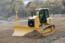
BF0BFE39-A3BD-4E96-B6C5-DE8DA791C6A7.jpegI’ve attached a pic of a machine control bulldozer. You can see a GPS unit on both cornerS of the blade.
 
   / Using GPS to lay out a field #63  
Brokentrack, you must have misunderstood me, I知 talking new construction. I gave the ditch as a simple example. They are usually much more complex, say a new box store or an entire roadway construction. The machine control does away with a lot of construction stakes and speeds up grading operations.

Yes, I did actually! That makes more sense.

As for the bulldozer, it looks like a D5??? We got one that is two years old that is fitted with them as well. My Grandfather hates it as he I old school, but he can be like that sometimes. One day I watched him drive up across my field because I had water bars in the road, and he REFUSED "to pound over them." (They were not that bad).

Where exact GPS really helps is with reclamation. When I was out to the Black Thunder Mine in Wright, Wyoming, they said when they get done, if a rock was on top of the ground before they dig the coal out, when they are finally done with the area, the rock is put back in the same spot. All the same terrain, slopes, topography, etc. It is like they never dug the 120 feet of overburden out, and pulled the 90 feet deep of coal out of the ground.
 
   / Using GPS to lay out a field
  • Thread Starter
#64  
Yes, I did actually! That makes more sense.

As for the bulldozer, it looks like a D5??? We got one that is two years old that is fitted with them as well. My Grandfather hates it as he I old school, but he can be like that sometimes. One day I watched him drive up across my field because I had water bars in the road, and he REFUSED "to pound over them." (They were not that bad).

Where exact GPS really helps is with reclamation. When I was out to the Black Thunder Mine in Wright, Wyoming, they said when they get done, if a rock was on top of the ground before they dig the coal out, when they are finally done with the area, the rock is put back in the same spot. All the same terrain, slopes, topography, etc. It is like they never dug the 120 feet of overburden out, and pulled the 90 feet deep of coal out of the ground.

What do they do with the missing 90 feet that they took out?
 
   / Using GPS to lay out a field
  • Thread Starter
#65  
You are probably right. Technology changes so fast. Enjoy your tinkering....


Where I'd really like to go with this is to work together with like-minded tinkerers. I worry that a lot of this technology is going to end up locked up in proprietary systems and out of the reach of tinkerers. I'd like to keep it available.
 
   / Using GPS to lay out a field #66  
The missing 90 feet usually ends up in a final cut. So the lands get put back the way they were but on on side of the mining operations there is a big long hole left that usually turns into a lake.
 
   / Using GPS to lay out a field #67  
The missing 90 feet usually ends up in a final cut. So the lands get put back the way they were but on on side of the mining operations there is a big long hole left that usually turns into a lake.

Yes, what you said...

What amazed me was, they could "Cast Blast" 1/3 of the overburden from the next cut, into the previous cut. Keep in mind these "cuts" are 300 feet wide, and 2 miles long. That is a lot of dirt to move by blasting alone! (The 180 cubic yard dragline dug out the remainder 2/3).
 
   / Using GPS to lay out a field #68  
I don’t think they will lock it up, it’s not really possible. Different makers in the surveying world have different attitudes. For example, the software in the data collectors. Some will work with any GPS system while others will only work with their brand. Like so many areas of business there has been acquisitions and mergers.

One of the big advantages of GPS is you can have unlimited number users. You only need a receiver. The math and computations would be simpler if you could send signals to the satellites and receive them back, but then you would have a limited number of users, kind of like channels on two way radios. As it is the satellites broadcast only, kind of like a TV station.

It wasn’t to long ago the US scrambled the signal, called Selective Availability. They turned that off during the Clinton years. It didn’t affect the surveying world but for a single receiver the accuracy went from 100 meters to 10 meters when Selective Availability was turned off. This was all for defense reasons that it was scrambled. The entire GPS was put up for defense reasons and other users started to figure out ways to use it.

Really getting off topic, but there is something called OPUS. It’s run by the NGS. There is something called static data. It’s where you just set the gps unit up and collect data. With a single unit you can collect from between 20 minutes to 2 hours of data, send that file into OPUS, and get an exact position with an elevation. It doesn’t sound like a big deal but it is when that position is to the nearest cm. I used to use this all the time but now I’ve got so many known points to set my base on I don’t need it.
 

Tractor & Equipment Auctions

2025 Unused Auto Darkening Welding Helmet (A49346)
2025 Unused Auto...
Honda Pioneer 1000 UTV (A50860)
Honda Pioneer 1000...
2014 MACK CHU TANDEM AXLE DAY CAB (A51219)
2014 MACK CHU...
2017 Chevrolet Colorado Ext. Cab Pickup Truck (A48081)
2017 Chevrolet...
2016 PETERBILT 579 TANDEM AXLE SLEEPER (A51219)
2016 PETERBILT 579...
2012 MACK GU713 DUMP TRUCK (A51406)
2012 MACK GU713...
 
Top