Need Surveying Advice

   / Need Surveying Advice #11  
I agree, pull your neighbors deeds and hope you find some recent references to locatable monuments. For example if that iron works parcel is a neat rectangle with a couple of corners known, that will help locate their corner that is common to you.

Also the county may let you see their survey file for the road.

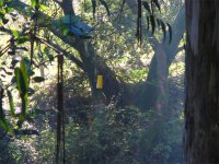
I took similar information and located some nearby known points onto Google Earth, then added the distance/direction for my lines. My back corners hit where Grandpa's old stories predicted. By chance the neighbor had those corners surveyed and monumented a short time after. My estimated side lines were found to go down the correct corridors between orchard rows, and the survey revealed I owned about 4 ft of width more on each side compared to my Google Earth estimate. I missed my back line, across the ravine, by 10 to 20 ft but since that is an impassible steep bank, my estimate had been sufficient for any practical purpose.

Attached: I went over with a ladder and added a 'witness monument' to the one corner I can see from my side of the ravine. It's a yellow newspaper delivery tube nailed vertical to a tree, barely visible at the center of these photos.
 

Attachments

  • P1050118rBackCornerWtele.jpg
    P1050118rBackCornerWtele.jpg
    127.2 KB · Views: 201
  • P1050123rBackCornerW.jpg
    P1050123rBackCornerW.jpg
    117 KB · Views: 417
   / Need Surveying Advice #12  
TNhobbyfarmer said:
OK, you asked for it. ...

Could be a LOT worse. Both parcels close mathmetically within 40' (precision ~ 1/300), which ain't good in today's terms but probably on par for the era and working conditions when written. Calls to adjoiners usually gives them priority, so as suggested, getting all surrounding deeds and subdivision maps, if any, would help shed more light ...
 
   / Need Surveying Advice #13  
Does it look like this? This may help you find your corners. How do these tracts piece together? I can add the ajoining info as well.
The first tract has a bad area calc with a 40' closure error. Really not bad for the distance involved. The area, even with the LEOC corrected is off by 8 or so AC. If you have some questions I try and answer them.
On a side note I've got to run down to NC to pick up some tractor tires and rims so I won't be back till Sat.
 

Attachments

  • TBNsurvey.pdf
    42.5 KB · Views: 244
  • TBNsurvey2.pdf
    37 KB · Views: 183
   / Need Surveying Advice #14  
Homebrew is spot on with the error. In VA for rural land you are allowed 1' in every 20,000'. You have 1 in 300. It can be adjusted to remove the error but we need to know more about where the probable error is.
 
   / Need Surveying Advice #15  
Nice work shaley. TN, where are the tracts in relation to the road?

If you find the original monument it will most likely hold over the distance calls in your description. If the call is 55 1/2 poles TO a tree or stake that usually means the tree or stake is the corner...think of the distance call as a finder.

You may not find the original stakes but you should look. You may find the original trees. If you know about where one of the corners is start from there. Use the distances and directions on shaley's map to look for the other corners.

Zeuspaul
 
   / Need Surveying Advice #16  
Thanks for pointing out the acreages shaley, I forgot to note that. Wasn't surprised at tract 1 being off but WAS surprised that tract 2 was correct :)
 
   / Need Surveying Advice #17  
the survey of my 4.7 acers reviled that my driveway was not on any deeded land. It also set the corners.

it cost another $500 or so to get the driveway area split between my neighbor and myself and that recorded.

For $2K i got a new plat registered with the county. for another $800 i had them topo about 2 acers around the house barn.

my wife works for the survey company.

A survey crew ill bill out at about $100 per hr. It took them about 2 days to survey the property correctly.
 
   / Need Surveying Advice #18  
I don't think there is a *bust* (mistake) in any one measurement. It is more likely random measurement errors. The calls are to the nearest half degree and the nearest half pole. 1/4 degree error in 10000 ft represents about 40 ft in distance. Factor in 1/4 pole error (4 ft) and the the closures are representative of the accuracies of the time.

It looks like they did not balance their traverses at the time which was probably standard procedure. So it would make sense to uses the old *raw* measurements and balance them today. However one would have to also look for the original trees and stakes (monuments) in the description and also look at the senior properties.

Zeuspaul
 
   / Need Surveying Advice #19  
zeuspaul said:
... original trees and stakes (monuments) ... Zeuspaul

With the magnitude of error in mind, I'd be happy to find anything that resembled an original monument within a ~20' circle of any calc'd position :)
 
   / Need Surveying Advice #20  
We only had a 3/4 acre lot surveyed but i remember the surveyor tellign us it would cost less nt he winter time when allt he leaves were down than in the summer, the lot was heavily wooded.
 
 
Top