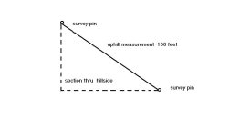
I can't answer the question as to how a surveyor would make the measurements, but you only have 100' in depth, and it doesn't matter if it is a hill or not. If you remove the hill, the measurements of the underlying surface are still going to be the same. Survey measurements are adjusted for hight and the map shows the ground as if there were no change of elevation. I can understand how they can do it with modern equipment, but how it was done with the old manual tools, is the question.
I had a piece of property in NH that I purchased in 1963, that the three of the boundaries descriptions were pretty much useless for surveying.... "from the big oak tree, to the stone pile to the snow pile, to the stream", or some kind of language such as that. I didn't pay much for it, and didn't get much for it when I sold it a few year later, but I always wondered how I would have had it surveyed. It contained about 50 acres, more or less. Probably, today, a attorney wouldn't even consider transferring a deed like that without having a better description worked out by a surveyor. When I purchased it, it was said that a lot of the deeds were like that and there was never a problem. 40 years later, I still wonder about this..... /forums/images/graemlins/frown.gif