Using GPS to mark property boundry

   / Using GPS to mark property boundry #21  
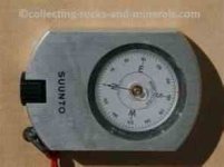
As a slight digression from the topic, I would like to mention that Suunto makes a very nice compass for professionals. I have used Suunto compasses and clinometers for years and recommend them.

I am not too handy at attachments, so if this does not come through please google "Suunto compass". It has an aluminum body and you sight through an eyepiece rather than use a mirror. It is more expensive but accurate to at least a degree and probably better. Might be able to find a used one on ebay... this is a very nice tool and worth owning if you have use.
 

Attachments

  • suunto_compass.jpg
    suunto_compass.jpg
    4.6 KB · Views: 124
   / Using GPS to mark property boundry #22  
Why not check with the previous owner at to whether there had been any problems or arrangements over the area and then write to your neighbour telling him you have just bought the property and would like to find out where the boundary lines are. get him involved and then you can help 'him' discover he is encroaching on your land. He would be far more accepting and a better chance of him being a friend for life. (well maybe just a friendly neighbour)
 
   / Using GPS to mark property boundry #23  
This is my tool of choice -- the Brunton Pocket Transit:

300.5008cp.jpg
 
   / Using GPS to mark property boundry #24  
I have a Sliva Ranger.

Years ago, well, it was more like decades ago, the NC parks department had a little compass class that I took. It was free. It was well worth more than I paid for the class. :D Now, I knew how to use a compass but the ranger had us figure out our step and stride length which was very valuable. We ran through some very basic "routes" the ranger laid out in a open field and off we went. I think these compass manual had something similar inside.

I used to go to a very large state park and walk the trails. The longest trail was 6.5 miles. An group had gone through the park and had made a very detailed map that included very old barbed wire fences, family burial yards, old huts, etc. The land was taken by the state in the 20-30's so that tells you the age of some of these places. That map was danged accurate. I started plotting courses off the trails using land marks on the map. I would count strides along a bearing to get a certain distance and the bear off on a new bearing. I could hit a very small target in the middle of very thick woods. That ranger was a danged good teacher. :laughing::D

Later,
Dan
 
   / Using GPS to mark property boundry #25  
I have a Sliva Ranger.

Years ago, well, it was more like decades ago, the NC parks department had a little compass class that I took. It was free. It was well worth more than I paid for the class. :D Now, I knew how to use a compass but the ranger had us figure out our step and stride length which was very valuable. We ran through some very basic "routes" the ranger laid out in a open field and off we went. I think these compass manual had something similar inside.

I used to go to a very large state park and walk the trails. The longest trail was 6.5 miles. An group had gone through the park and had made a very detailed map that included very old barbed wire fences, family burial yards, old huts, etc. The land was taken by the state in the 20-30's so that tells you the age of some of these places. That map was danged accurate. I started plotting courses off the trails using land marks on the map. I would count strides along a bearing to get a certain distance and the bear off on a new bearing. I could hit a very small target in the middle of very thick woods. That ranger was a danged good teacher. :laughing::D

Later,
Dan

Anyone with the interest and a local course should take it, particularly if the course is offered by forestry/ranger professionals.

I have worked with boundary lines and land navigation at a professional level for over 30 years. You would be very surprised to see how precise you can be in navigation/surveying given training, discipline, and maps/aerial photos.

I have often gone 10-12 miles in a day on timber cruise lines (with systematic sample plots as the objective) drawn on aerial photos or maps. Not unusual at the end of day to come out within a few hundred feet of the truck both in distance and bearing. All with a hand compass and pacing. This is a skill that can be learned and it is really satisfying.
 
   / Using GPS to mark property boundry #26  
Remember too that just because you find a pin does not always mean it is ON the line. It might be offset because of some obstruction on the property line (or at the corner like a tree or rock) that would not allow for a shot to be made with the instrument or the pin to be placed exactly on the corner.
 

Tractor & Equipment Auctions

2016 Ford F-150 Pickup Truck, VIN # 1FTEX1CG6GKF21612 (A48836)
2016 Ford F-150...
2018 Toro Grounds Master 7200 72in Zero Turn Commercial Mower (A50324)
2018 Toro Grounds...
INOP/NON-RUNNING Clark Wheel Loader (A48837)
INOP/NON-RUNNING...
(1) HD 24ft Free Standing Corral Panel (A48837)
(1) HD 24ft Free...
UNUSED LANDHONOR DDSL FUEL TRANSFER PUMP (A50460)
UNUSED LANDHONOR...
2020 Ram ProMaster 1500 Van, VIN # 3C6TRVAG5LE100108 (A48836)
2020 Ram ProMaster...
 
Top