Using GPS to mark property boundry

/ Using GPS to mark property boundry #1  

Tollster

Veteran Member
Joined
Feb 26, 2005
Messages
1,418
Location
Benton, Pennsylvania
Tractor
Kubota, BX23
Any one ever try it? I have 2 pins about .25 mile a part, unable to maintain a visual on marker due to elevation changes and thickets.

I gave it a shot today, went to the southern most pin and plotted a way piont to the other. Hung tagging every 20-50 yards or so, then saved the new tagging locations as waypoints.
Came home and imported the image in Garmin base camp, then drew a straight line from pin to pin, through the new tagging waypoints.
They are pretty close, I have 4 tags that are out about 10-30 feet or so,but about 50% are spot on.

I have a garmin Oregon 400t, but had trouble setting it up.I could not find a course deviation setting anywhere in the unit. I also could not set it up so the course was aways facing up.
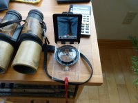
I recon I could get a topo map and do it the old way, charts and compass...

Heres one for ya'll. Just got the property and traced the boundry, the neighbor is over the line by about 150', he actually has no hunting signs and a large portable tree stand. Any ideas on how to be neighborly but not a smart *** on getting his **** back on his land?

I was thinking about removing the signs and hanging some sort of letter on the stand. Bottom line is I wanna get a long with the neighbor and I am the new guy in the area. Don't mind him hunting, but the postings are ....over the line!
 
/ Using GPS to mark property boundry #2  
You may have to hire a pro surveyor.You didn't when you purchased the property?They will use a GPS also but,he is more apt to believe their lines.
After that;just notify the persons involved.The longer it goes the worse it will be.
In NY...we have access on the web to property lines;useing bing maps and tax maps.You may want to check if this is availble in your area.
 
/ Using GPS to mark property boundry #3  
I agree have it professionally done, then you can walk next store and say you just had the place surveyed, show him your maps and were he has posted. If you don't mind him hunting, I would tell him that's okay but you are not good with him posting your land. Don't know how you feel about posting your side and if that works for you he should be good with it to. You may want to give him something in writing about the hunting priveledge as well, so later he can't come back with any claims or send his buddies your way.
 
/ Using GPS to mark property boundry #4  
I have a garmin Oregon 400t, but had trouble setting it up.

I have the Oregon 550 I use for Geocaching. I have tried to mark things on my property with it just for general locations... anything more will require a surveyor.
 
/ Using GPS to mark property boundry #5  
If he is a neighbor its best to just go talk to him first. Ask him how he figured the property line. Them say what you have to say depending on what he tells you. It is possible the previous owner of your property was fine with his markers. Can you find any evidence of where the line should be. Blazes, old fence, stone walls ? I did a rough survey of my property with my GPS so I could make a map. I use a MapTech program to import markers from my GPS. Then I can transfer them to Google Earth and draw a line. Maybe you could see something that way if it is not just all homogenious woods. If it comes to an arguement the only answer is a surveyor. I would want a 1300' line marked properly and legally if it were me.
 
/ Using GPS to mark property boundry #6  
I have done it, but the trees are so thick on my new property that line of sight to the sky is marginal, so the GPS accuracy is not great. What I normally do is just shoot a bearing from a known marker and then follow it, leaving intermediate ribbon markers.

A pro surveyor gets around this sort of tree problem by using differential GPS. They set up base stations where they can get a clear line of sight to the sky, and then triangulate back to the base stations with other techniques.

Using satellite imagery, it's possible to correlate location to tree types. I can walk my forest, and make note of certain tree types or groupings. Then pick them out on the sat image later and draw in a marker. I often use this as a sanity check on other measurements.

I have found that the "Theodolite" app for the iPhone is really helpful -- it's like using a surveyors transit without having to rent the real equipment. I also rely heavily on my Brunton Pocket Transit.

Recently I used all these techniques to walk the perimeter of my new 4 acre property. I came back out to the starting point and was within 6" of the pin. I thought that was pretty good, but I imagine a real surveyor can do much better.
 
/ Using GPS to mark property boundry
  • Thread Starter
#7  
If he is a neighbor its best to just go talk to him first. Ask him how he figured the property line. Them say what you have to say depending on what he tells you. It is possible the previous owner of your property was fine with his markers. Can you find any evidence of where the line should be. Blazes, old fence, stone walls ? I did a rough survey of my property with my GPS so I could make a map. I use a MapTech program to import markers from my GPS. Then I can transfer them to Google Earth and draw a line. Maybe you could see something that way if it is not just all homogenious woods. If it comes to an arguement the only answer is a surveyor. I would want a 1300' line marked properly and legally if it were me.

Thats pretty much what I did, the two southern pins are clearly idnetified, I plotted a straight line using waypoint to waypoint, then saved the flagging locations to my GPS. Came home and used a straight line tool in the GPS program to see how the lines fell. Exported to Google earth.
The neighbor does not live in the area, and only uses for hunting. I will remove his signs and leave him a kind note on his tree stand. Introducing myself and leaving my phone number as i would like to speak to him. I see how that transpires.
Either he'll call me, or pack up his stand and hide. That will tell me his place on the property and give an indication on what he knows.
 
/ Using GPS to mark property boundry #8  
Hire a professional surveyor! I do this for a living don't waste your time trying to mark your lines yourself or what you think are your lines. Hire a local respected/established professional tell him to mark your lines and every couple of years recut and mark the lines yourself. There is almost no way a layperson can mark a line anywhere close with a consumer grade GPS unit it just doesn't have the accuracy built in to it. And if the lines are in the wood your professional will not be using GPS.
 
/ Using GPS to mark property boundry #9  
I thought commerical grade GPS had a +-3 Feet accuracy scope.

Isn't that a bit much for a property line? Especially over many acres?
 
/ Using GPS to mark property boundry #10  
I agree have it professionally done, then you can walk next store and say you just had the place surveyed, show him your maps and were he has posted. If you don't mind him hunting, I would tell him that's okay but you are not good with him posting your land. Don't know how you feel about posting your side and if that works for you he should be good with it to. You may want to give him something in writing about the hunting priveledge as well, so later he can't come back with any claims or send his buddies your way.

Do not give anyone written permission to hunt on your property. In most jurisdictions this makes you legally liable for damages if an accident occurs.

In Louisiana it is illegal to hunt on someones property without written permission so if there is an accident, they are trespassing and it is much harder for you to found at fault even if you gave them verbal permission.
 
/ Using GPS to mark property boundry
  • Thread Starter
#11  
Hire a professional surveyor! I do this for a living don't waste your time trying to mark your lines yourself or what you think are your lines. Hire a local respected/established professional tell him to mark your lines and every couple of years recut and mark the lines yourself. There is almost no way a layperson can mark a line anywhere close with a consumer grade GPS unit it just doesn't have the accuracy built in to it. And if the lines are in the wood your professional will not be using GPS.


Did that the first time, he is the one who showed me the corner pins. He says he is currently 7 months behind, and everyone else,just as bad. Youngest one in the area is 63, none can get around well much any more. Claimed the new laws make it next to impossible to cert anyone, and when younger people look at the wages and training involved, they shy away from the trade.
I did tie into some other markings that where rather sporatic, but none the less intermittent along the line of travel.
I feel pretty content with the GPS, and since nothing much more than a sign will be within 200 feet of it, I'll mark it off for now until I can find someone.
 
/ Using GPS to mark property boundry #12  
I do not know how old your piece property is. If it is an old survey you and the neighbor may own the same piece of ground. The old surveys were not accurate at all and the owners just didn't care that much about a few acres unless it had a spring or other "useful" feature. In Maryland the oldest survey is usually considered the "legal' one. My great aunt paid taxes on 3 acres of land that just plain did not exist. When we sold her property it was surveyed and found that what she thought was hers actually belonged to the adjacent farm.
 
/ Using GPS to mark property boundry #13  
I would do more than just move stuff and leave a note. If you are not looking to build a fence and want the boundary to be open, then all you really want is for him to not build on your property and also not try to keep you off of it as you previously stated. I would find his mailing address through the tax office or county deed records and send him a letter. Offer to work with him to find an approximate property line. Show him a photo (maybe mail a Google Earth image and overlay the property lines). Tell him exactly how you have come to this conclusion the same way you described it to us.

If he will accept none of the above informally, then you need to talk to a surveyor about a property line survey with clear marks. I've had to do that on one of my properties. After the guy saw where the property line was, he ended up hating his land so much that the forfeited it back to the State of Texas. You just never know what somebody will think or do. Your neighbor may be a super nice guy as one of mine is or a real pain. You have to approach the situation based on that.
 
/ Using GPS to mark property boundry #14  
Tollster said:
Did that the first time, he is the one who showed me the corner pins. He says he is currently 7 months behind, and everyone else,just as bad. Youngest one in the area is 63, none can get around well much any more. Claimed the new laws make it next to impossible to cert anyone, and when younger people look at the wages and training involved, they shy away from the trade.
I did tie into some other markings that where rather sporatic, but none the less intermittent along the line of travel.
I feel pretty content with the GPS, and since nothing much more than a sign will be within 200 feet of it, I'll mark it off for now until I can find someone.

Wow 7 months behind wish we had that problem here!
 
/ Using GPS to mark property boundry #15  
You cannot consistently get an accurate read on a consumer GPS. These units are routinely off by 30' or more.

The surveyor's equipment reads the satellite signals from a known data point and transmits a signal with correction information to the portable unit so the portable unit can calculate the correct location. The portable unit reads the satellite info, and then corrects the readout based on the information from the transmitter on the known data point. I've been told the surveyor's equipment is accurate down to a fraction of an inch.

The surveyor's equipment is rather spendy as some would say.
 
/ Using GPS to mark property boundry #16  
I thought commerical grade GPS had a +-3 Feet accuracy scope.

Isn't that a bit much for a property line? Especially over many acres?

Consumer grade GPS units only resolve to at best 12 maybe 8 or 6 feet.
Survey grade GPS units are sub-centimeter accuracy. If you had a differential GPS unit attached to your GPS (provided it even has that capability) then you might get repeatable ~3 foot accuracy over short distances (under 1/4 mile).

Hire a pro. His work will stand up in court. You should have had your lines marked when you bought the place and maintained them as was previously pointed out. It's work yes but pays off as you avoid conflicts like you are in right now.
 
/ Using GPS to mark property boundry #17  
Two sides of our land have pins every 300 feet or so which makes keeping the property line cleared and marked easy. The other two sides though are problem since the pins can be 700-800 feet apart. In one 800 foot line I got a surveyor to put in a pin, should have had them put in more than one pin, between the corners. It cost me $300-400 almost a decade ago but it has "solved" at least two property line issues.

For the other other lines that have pins far apart I use a compass to find the line. I only do this to put up trespass signs. A real dispute would require the surveyor. A compass if much better than a GPS at running the line. I start at a known corner pin, find a tree as far as I can see on the correct property line bearing and put up flagging to that tree. Then repeat to the other corner or near to depending on the brush. After one corner is done, I go to the other corner and shoot the bearing towards the other corner and start putting up flagging or adjust already placed flagging. Once you get up enough flagging you can see the line through the woods.

It is best to do this in the winter after the leaves have fallen. :D

I do have a survey with the property lines bearings.

This works real well for putting up no trespass signs if you have two corner pins. I would not use this method to put up a fence though.

A consumer grade GPS is just about useless trying to do this in our heavy woods. Its close. It helps but the compass is better and the tree cover does not effect the signal. :laughing: I have used the GPS to do this and I will in the future to help get close to the line between pins in heavy brush but the compass is the final tool to use.

Later,
Dan
 
/ Using GPS to mark property boundry
  • Thread Starter
#18  
I thought about doing line of sight and a compass as you suggest. I can get a 1;24 topo, orient my declination, and using UTM condinates for the GPS, utilize the 3 known points of refernce visually, then plot it on the topo using UTM grids (10,000 x 10,000 square feet), then utilize the GPS as a third verifier, pretty much walk the border using the GPS, combined with the compass. I have had s lot of luck using it ofr hunting pruposes in this matter, as well as finding my way ut of the woods when the batteries died.
I believe the survey years of the map is 84 USGS.

Many of the surveys in our area have refrained from using GPS instruments due to the high level of auracy, as strange as this may sound, you have to consider in the day of william penn and such, if their zero reference was off even the slightest bit, this margin of error could be much greater as deeds grew, kind of like being off .25" in the basement and then having it be an 1.0" off on the second floor. So if you where apt to use something as precise in this day and age,it could potentially create more problems with known reference points across the commonwealth of Pennsylvania.

I like the isea about presenting my findings with the neighbor and really hope we can work things out. I wanna be his friend when he needs a hand and so on, rather than your run of the mill smuck. I wish I could talk to the owner of the property and see if they had spoken to him. We are due to close 1/13 on the parcel, so I have choosen not to be aggressive, but none the less something I know I need to resolve right away as the new owner.

Thank you all and Merry Christmas,
Tol
 
/ Using GPS to mark property boundry #19  
Boundary surveys -- or more properly boundary line location -- are part of my forest management business, but I am not a licensed surveyor and stay away from anything beyond my abilities and expertise.

First, as others have suggested, a homeowner grade GPS is of no value here. If you have known reference points, pins, corners, etc. and a deed description that includes bearings and distances then you should have little problem establishing a line. Provided the corner pins are located where they belong... I have often seen landowners move them around to suit their wishes.

You need a good compass such as Silva, Suunto, or Brunton adjustable for magnetic declination. They will have a mirror for sighting, and properly used will be accurate to 2 degrees or better. Dial in your bearing -- be sure to note whether the bearing is true or magnetic north -- and sight as far away as you can. Hang flagging as precisely as possible to centerline. Move up to the flag and repeat. When you get to the corner turn around and run the line back to starting point, adjust flagging to reflect the average line center. Look carefully along the way for supporting evidence, i.e. old fence, pipes, blazes or paint on trees.

This is not precise, but you will be surprised how close to true a line is when done carefully. I run lines in the thousands of feet to miles range and make them work out. I appreciate the problem with the neighbor, it is not uncommon. It can be helpful to ask him to meet with you on the line, walk it together and show him the evidence and flagged line and pins. Be cordial, he may agree with you. If not, you can still have it surveyed.
 
/ Using GPS to mark property boundry #20  
What dmccarty and Eastinlet say is good advise. Around here boundries are flagged all the time for logging operations by the land owner or forester with a compass. This is a Silva Ranger with a sight, not expensive, but with a little practice you can flag a straight line. Your surveyor who found the pins may be able to give you a magnetic heading from his field notes.
 

Attachments

  • Compas.JPG
    Compas.JPG
    370.3 KB · Views: 207

Marketplace Items

UNUSED JCT HYD AUGER DRIVE AND BITS (A65055)
UNUSED JCT HYD...
Medlin Yard Truck Ramps (A64556)
Medlin Yard Truck...
2022 EZ-GO ELITE ELECTRIC GOLF CART (A63276)
2022 EZ-GO ELITE...
2025 IRanch IRTPL 10,000lbs. Two Post Automotive Lift (A64194)
2025 IRanch IRTPL...
2025 Mini Bucket Excavator Attachment (A64553)
2025 Mini Bucket...
2016 Audi A6 AWD Sedan (A64557)
2016 Audi A6 AWD...
 
Top