You are using an out of date browser. It may not display this or other websites correctly.
You should upgrade or use an alternative browser.
You should upgrade or use an alternative browser.
yet another pond
- Thread starter OkeeDon
- Start date
- Views: 14144
More options
Who Replied?
/ yet another pond
#21
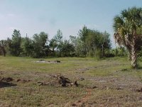
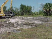
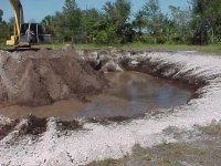
Another angle, across the pond location and looking towards the front of where the house will be. The house will be more or less centered on the oak grove in the background. The tractor is "under water". Today was the last time I'll be able to park it there!
Attachments
Junkman
Super Member
Where are you going to put all the dirt that comes out of that huge hole when it is done? Do you have any idea of how many yards you are going to be moving?
Actually, we really didn't want a pond in the first place. Extra maintenance, extra costs, potential mosquito breeder, danger to the grandchiildren, attracts unwanted wildlife. All of this, however, was overshadowed by the cost of hauling in at least 1600 cubic yards of fill - estimated before the record rainy season we had this year. I really don't know how many yards of fill we'll need now to get the drainage working - it could be 2000 yards or more. The plan is to dig the original pond layout, move and grade the spoil as fill, then take at look at where we are. If the property has not been raised enough, we'll keep digging, even though it may be a budget buster.
In a way, I consider myself fortunate that we had the record rainfall in the past 3 or 4 months - if I had not seen how bad it could get (4 out of 5 acres were under at least 6" of water), I would not have known how much to build it up.
Our house alone has to have a minimum elevation 4' 6" above the present ground level. We won't be building the dirt up that high; even though most houses in Florida are built on monolithic slabs, we're going to build the house area up about 2', and then put the house on stem walls. The barn area will be built up about 2', and the entire road (about 800' x 12' has to be raised at least a foot.
While this pond will cost between $6K and $10K, the fill at local rates would have been at least $15K, and that's without the grading and compacting costs.
As you can see, getting rid of the dirt is the least of our problems.
Junkman
Super Member
just hope that they don't find any dinosaur bones!!!!!!!
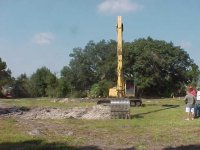
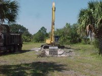
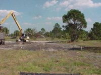
Now we get to the good stuff. Like everything else, though, nothing is as simple as it seems, and there is always preliminary work. In this case, they won't start to spread the fill until all of the organic material has been skimmed from under the house pad. I staked out the actual house (minus porches and pool), and they skimmed the grass.
Attachments

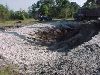
Now, on to the pond. First cut. Turns out the operator is color blind and can't see the orange paint line on the green grass. So, I started putting stakes every few feet all around the perimeter, leapfrogging them as he finished one section and moved to the next.
Attachments
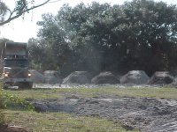
These guys think of all the details. They only want good, clean fill under the house and barn, so first they skim all the grass off the top of the pond and use that for fill in less important areas, like the low spots out along the highway. This also gives them (and me) and good outline of the pond.
Attachments
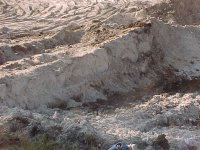
I've mentioned a few times in other threads that Florida "soil" is pretty much sand. Here's the proof. The nearly pure white sand goes down about 6', then there's a layer of semi-clay-like hard pan. Sometimes there's muck. At some point, we break through the pan and get to sand again, but it's not usually as white as this. This is really virgin soil - oops, sand.
Attachments
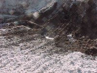
Here's the first water to trickle in. By morning, there will be a lot more. The real surprise for me was how far down the water table is, considering that 3 weeks ago, there was 6" oof water on the surface and nothing was seeping into the ground because of saturation. There is a possible explanation. The water in the drainage ditch between my land and the highway runs down about a mile to a slough (pronouced "slew"), then runs to Lake Okeechobee. The Lake is at record highs, and they did not open the flood gates on the slough until 3 weeks ago. Essentially, my land was part of the holding reservoir. Once the gates were opened, the water ran off pretty quick, and, with very hot, sunny days, no rain, no water to seep in, the water table dropped pretty quickly.
There's a lot more to that story. The lake is high because years ago, they straightened the Kissimee River to a drainage canal, draining half the state into the lake. At the same time, they diverted the flow from the lake away from the southerly swamps in order to promote agriculture - that's where sugar and winter vegetables are grown. In order to get rid of the water, they dug cross-Florida canals to the East and West of the lake and installed a series of locks. Now, when the lake is high, they release water to the East and West. The problem with that is that they are releasing fresh water in brackish estuaries, which kills the fish and other water life which depends on mild salinity. That's what happens when you fool around with nature...
There's a lot more to that story. The lake is high because years ago, they straightened the Kissimee River to a drainage canal, draining half the state into the lake. At the same time, they diverted the flow from the lake away from the southerly swamps in order to promote agriculture - that's where sugar and winter vegetables are grown. In order to get rid of the water, they dug cross-Florida canals to the East and West of the lake and installed a series of locks. Now, when the lake is high, they release water to the East and West. The problem with that is that they are releasing fresh water in brackish estuaries, which kills the fish and other water life which depends on mild salinity. That's what happens when you fool around with nature...
Attachments
BradK
Bronze Member
I know what yah mean about too much water this year done. The rear of my property has been under 3-6 inches this year also. I need to have my pond cleaned out and one end made deeper. I could use the fill on the rear of the property to stop the water from my neighbors property.
jinman
Rest in Peace
- Joined
- Feb 23, 2001
- Messages
- 21,059
- Location
- Texas - Wise County - Sunset
- Tractor
- NHTC45D, NH LB75B, Ford Jubilee
Don, do you have a drawing or some plans you could take a photo of or scan? This looks like a really interesting long-term project and I'd like to see what you have planned when things are "complete."
Your sand and layered soil looks very much like my own. I have deep erosion gullys, and I see layers of white sand and red clay that are 6' to 8' thick. If I couldn't see your tropical trees, I wouldn't guess Florida at all. ...just shows you what I know. /forums/images/graemlins/blush.gif
Your progress is really exciting. Please keep those pictures and good descriptions coming. /forums/images/graemlins/smile.gif
Jim. the drawing for this project is found in just one place - on the ground. For several months, waiting for the rains to end, I had been looking at the property from every angle, and looking at other people's ponds. I knew pretty much what I wanted and could picutre how it would look.
So, the evening before this was to start, I walked out with a couple of cans of orange marker paint and one of the trigger thingies that places the can close to the ground, and drew my pond "full scale". I knew that I wanted a somewhat irregular shape to try to make it look more natural, but some of the bumps and jogs I drew were too sharp to be executed with the slopes, and the drawing was "revised" on the spot when the hoe started skimming the grass. So, you could say that the final shape was sculpted rather than drawn...but, essentially, it's a little like a 1/4 acre amoeba, with the shape determined by proximilty to the surrounding trees and palms.
I'm not even certain of the actual size - while they were skimming it, I sorta walked from here to there, and then from halfway around from there to half way around from here, counted paces and converted to feet, multiplied one against the other with an imaginary fudge factor to acount for irregular shapes, and came up with the possibility that it was less than 11,000 square feet but more than 9,000 sq ft, so I called it 10,000.
Here's the pix from Friday. The night before I showed a tiny trickle of water and said there's be more in the morning. Sure enough, there was more the next day. Remember, whiile rainfall might produce a slight increase in water depth, the water in this pond will come naturally from the water table, and later from the well to keep it at a constant level.
Attachments
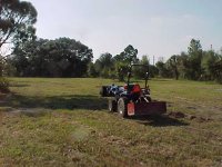
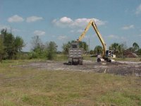
In the meatime, while the dump truck stacks up loads of fill for the house pad, the contractor brought in an articulated wheel loader and started moving excess dirt form where the trash was buried to the road. This isn't necessarily the most efficient way to do it, but the loader and operator were available for the day (in between other jobs), so the contractor put her to work "bucketing" the fill. I'm paying a flat rate per ubic yard no matter how much equipment is around, so I don't really care how efficient it is.
Attachments
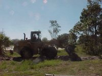
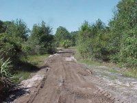
She's building the road up in stages - she's put down 8" to 10" on the first pass, and repeatedly traveled over it to compact it. Then, they'll add another layer and grade it with the dozer, which will also compact it pretty well. The final will be about 12" above the current level. Later, I'll add about 6" of shell rock to stabilize it. That will have to be trucked in.
Attachments
Here are some similar links:
- Replies
- 34
- Views
- 6K