KennyG
Super Member
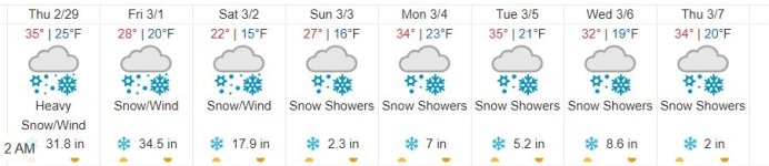
We went from 65 and sunny yesterday to blowing snow this morning. But spring is just around the corner...maybe.
 Lake remains open.
yep, woke up to 6 inches of this yesterday. turned to rain at noon and left behind slop. Ran the blade up and down the driveway so UPS could deliver.Yesterday - 2/27 - was bright sun shine. Went outside - Brrrrr.
26F and windy. It was a quick trip.
That’s a great picture someone took.yep, woke up to 6 inches of this yesterday. turned to rain at noon and left behind slop. Ran the blade up and down the driveway so UPS could deliver.
View attachment 854854

I'm sure you all are disappointed, but the groundhog warned youThis might be the end of grooming for us. View attachment 854971

It's like they have seen the Jerimiah Johnston Movie!That IS a great pic - Robert. Notice - the deer are broken into two groups. Those who fear the heavy snow load on the trees may fall on them and the fearless ones.
Now - if I were standing under those trees - the "branch load" would have already fallen on me!!!