GPS to create a map of my property???

   / GPS to create a map of my property??? #11  
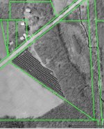
Interestingly, I just finished up a three day course (my second one) on ArcView 3.x This program does exactly what you're talking about, but it's expensive ($1k), and fairly complicated. It's put out by ESRI, and is THE software for representing map data visually.

We will be using it at my office to map aquatic vegetation/habitat coverage year-to-year; create contour maps for some of our smaller lakes; and i.d. sampling locations with hotlinks to data.

Of course, I'm just a novice right now, so I'm pretty useless to ask questions of. But from what I can see, if you already have a computer (preferably a laptop), a decent gps such as a Garmin Etrex, and the ability/desire to be a technoweenie, this software would be a very cool addition to anyone's planning kit. Just keep in mind that even WAAS enabled GPS units are only accurate to within 3 meters. My understanding is that within 5 years, we'll have basic units accurate to within 10 cm. Right now you can only get that accuracy from expensive units like Trimble.

Oh, one other thing. There may be programs with less functionality out there that would suffice. I'm just not familiar with them.
 
   / GPS to create a map of my property??? #12  
I have a Lowrance GM-100 that I bought about 10 years ago. There's a program called Ozie Explorer that allows the user to modify the maps within the GPS. I've been able to add roads, streams, etc. fairly easily after using it a while. I bought the GM-100 because at the time the Lowrance models were the only ones that would work with it, but I'm not sure what's available now. I recommend that you look further into this for what you want to do.
 
   / GPS to create a map of my property??? #13  
Didn't you get a map of a survey when you purchased? Every piece of property that I have dealt with had a survey that came with a map that was registered with the county. If the GPS is accurate to +- 3 meters, you could be off your mark by +10 feet at any given time. Not too good when digging for utilities. /forums/images/graemlins/shocked.gif

I've taken my survey maps and scanned them in to my PC. Then I can print them out whenever I want a copy, manipulate them in picture formats, save them as backgrounds to CAD programs, etc... From that point on, when I want to record the location of something, like the septic tank lids, I just measure from two unmovable points, like two corners of the house or garage, record the distances and copy them onto the maps.

Do like the Doc said and get a map from the county. Your place will be on it. /forums/images/graemlins/wink.gif

Our county even has them on-line. You can display a map of the county, select the option to show all parcels, zoom in on your parcel and see an aerial photo like the one I have attached. Then you can select another option and click on a parcel and it will tell you the legal description, measurements of all sides, who owns it, when it was last assessed for taxes, etc...
 

Attachments

  • 544784-Image1.jpg
    544784-Image1.jpg
    86.7 KB · Views: 154
   / GPS to create a map of my property???
  • Thread Starter
#14  
My land was nothing but timber when I bought it. I have three surveys on it so far and will probably end up with a few more by the time everything is said and done. The last survey in August cost me $9K and it just lined up some boundry changes and consolidated all my parcels into the right legal description for my project.

I have arial and topo maps. They are nice and have helped tremendously.

I'm cutting roads into my land, clearing pastures, pads and ponds. The place is changing on a monthly basis.

To keep up with everything, I'd like to be able to create a PLAT with all the information on it. Underground utilities will be labeled.

Exact positions arent as important on the map as it is to have a reference that says the cable is 3 feet down and 6 feet south of a certain fence post or street light. I can then color code each utilitie and know where it is.

Notes and sketches get confusing to me and in a few years I'll really wish I'd done this when I had the chance.

It seems the GPS will give me some reference points. The software is extra, and from what I understand, it's gonna be the real concern for what I want to do.

Thanks,
Eddie
 
   / GPS to create a map of my property??? #15  
One Call Contacts has the phone numbers for evey states "One Call Before You Dig" centers. In Texas call (800) 245-4545 and tell them you need all utility lines marked because you are about to start trenching all over the place.

All the utilities have to come out within 48 hours and mark all lines for you, even overhead phone lines.

If they mark the lines and you cut a line that they didn't mark you are not liable. If you dig before you call and hit a line guess who gets to pay for the repairs?

They will mark all that stuff for you.

Be aware that some gas companies are using plastic line. Don't ask how I know that. At least I admitted that it was my fault and the gas company didn't bill me for the 5 guys and 2 trucks that showed up to repair the cut. If I had tried to BS my out of it I'll bet I would have been stuck with a $200 to $300 bill.

Did you take into account the Magnetic Variation when taking your compass readings? If not your readings will all be way off. We get into "True North", "Grid North", and "Magnetic North".

According to Scouting Resources

"The important thing here is to remember that a compass points not to true north (e.g. the north pole, the geographical northernmost point of the Earth) but to magnetic north (the magnetic north end of the Earth's 'bar magnet'). These two are not in the same position (indeed the position of magnetic north varies with time)."

Now you know that North on your compass is not really "North".

When I was in the Artillery branch of the US Army we had to set the declination on your aiming circles every 6 months to compensate for the magnetic variation.

BTW, I have a Garmin Map76 that I really like. Has a larger screen that the Etrex models.

I also have the USGS 1:24,000 maps for TX, NM, AZ, CO, and UT on my laptop so I can track myself on the 4 wheel drive trails. Neat setup, but with GPS, laptop, inverter, maps, etc. it runs into the $3,500 price range. The laptop was the expensive part and I actually already had it so it was only $1,000 extra for the other stuff.

Like everything else these days it is more complicated than it appears to be at first glance.

Bill Tolle
 

Tractor & Equipment Auctions

UNUSED FUTURE SZYMJ HYD STUMP GRINDER (A51248)
UNUSED FUTURE...
2020 KENWORTH T680 TANDEM AXLE SLEEPER (A53426)
2020 KENWORTH T680...
2016 R and R Products 331 LP Reel Mower (A51691)
2016 R and R...
2023 MAXEY G8X 26FT TILT BED GOOSENECK TRAILER (A53426)
2023 MAXEY G8X...
UNUSED HURRICANE D6028 JOB BOX (A51248)
UNUSED HURRICANE...
2018 TAKEUCHI TL10V2 SKID STEER (A51246)
2018 TAKEUCHI...
 
Top