I use Google Earth Pro (it's free, not to be confused with Google Maps). I don't really like their smartphone app, but accessing it from their desktop app works well for me.
Originally, to define my property boundaires, I found the survey pins with a handheld GPS and recorded the location. I then recreated those waypoints by manually entering them after clicking on the waypoint icon in Google Earth. Then I used the polygon tool in Google Earth to "connect the dots" and draw my property outline. It was a bit clunky, but this was years ago, and my GPS would not connect with my Mac Computer to upload the data. It's still possible to do things that way, but there are easier ways now.
You can use a smarphone app like GaiaGPS to gather the data: the free version will let you record waypoints, or walk trails and record them, you can then access GaiaGPS via a web browser on your desktop computer. It will display on a map, and you can choose various background laters (I usually choose USGS Topo for my background, since the satellite view of my property mostly just shows an unbroken forest canopy, other than at the house, yard and pond.) GaiaGPS does have a pay version that gives you more choices for background layers - including parcel boundaries. It runs $40/year. If I were just interested in my own parcel or a couple in my neighborhood, I'd just find pins and manually enter data for parcel boundaries. As an alternative, if I didn't want to spring for the $40/year, I'd buy it for one year and draw in the boundaries I wanted by copying what was displayed, save that data, then let the susbcription run out at the end of the year. (Some towns or counties have parcel data available in a form you may be able to import as well, either into GaiaGPS or Google Earth)
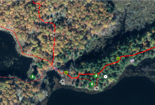
GaiaGPS on the smartphone is handy while hiking, or when trying to lay out a new trail, since you can see where you are on your property. I set it to record when walking my trails, and now have a record of my trail network. Since I like Google Earth's map display & editing options better, I export the data from GaiaGPS as a KML file (which is Google Earth's file format) and bring it in to Google Earth. I can edit the trail data to correct errors, or if I'm feeling ambitious, I'll record the same trail multiple times, then draw the best fit of these recordings in Google Earth (this helps overcome some of the GPS errors inherent in consumer GPS units or smartphones.) See below is what I end up with from Google Earth displayed on a Satellite photo. It shows property boundaries, trails, and I have "enhanced" the wetlands and streams to make them show up better. I also have a lot of other data, such as layers showing the stands in my forest management plan, obstacles on our obstacle course, problem areas where trails need to be rerouted or repaired, and the location of various places of interest (such as an ancient Sugar Maple or a porcupine den). I leave those layers turned off most of the time.

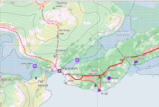
Since I'm not nuts about what I've found for options within Google Earth for displayin gthis on a topo map, I export my Google Earth data as a KML file, and input it into CalTopo. After tweaking some display settings (choose "Map Builder Topo" and turn on 10 ft contour intervals, edit colors of displayed data, etc.), here is what I get for the same general area (includes my neighbor's property to the north). I can export this to a JPG file (as shown here) or a geo-referenced PDF.
Other than the subscription to GaiaGPS premium service to get the parcel data, all of the above is free (I can't recall if I paid $5 or so for the GaiaGPS app without the parcel data, but the basic service is free these days).
There is a bit of learning curve, but it's a
lot easier than learning how to use dedicated GIS software. I still come across interesting features, from time to time.
Just remember that none of the data you see in any of these apps is "survey grade". You can use it to get close to your property line, but don't rely solely on it to show you where to build a fence or to establish the boundaries of a timber harvest. I've found places where the boundaries shown are shifted by 50 feet or more. Similarly, the data you gather with a handheld GPS or smartphone GPS app will get you close, but not right on. Use it to get you close, but then look for better information: survey pins, blazes on trees, or old fences referenced in a property survey.
") , and put that into QGIS. Then surveyed myself with compass and laser distance measurer all the newer animal races, and fences, tanks etc. Fences and gates are on one layer, tanks and water pipes on another layer, tree lanes on another etc.
, and put that into QGIS. Then surveyed myself with compass and laser distance measurer all the newer animal races, and fences, tanks etc. Fences and gates are on one layer, tanks and water pipes on another layer, tree lanes on another etc.